Rikers Island Before the Jail
A Colonial Farm, Family Estate, and Lost Queens Landscape
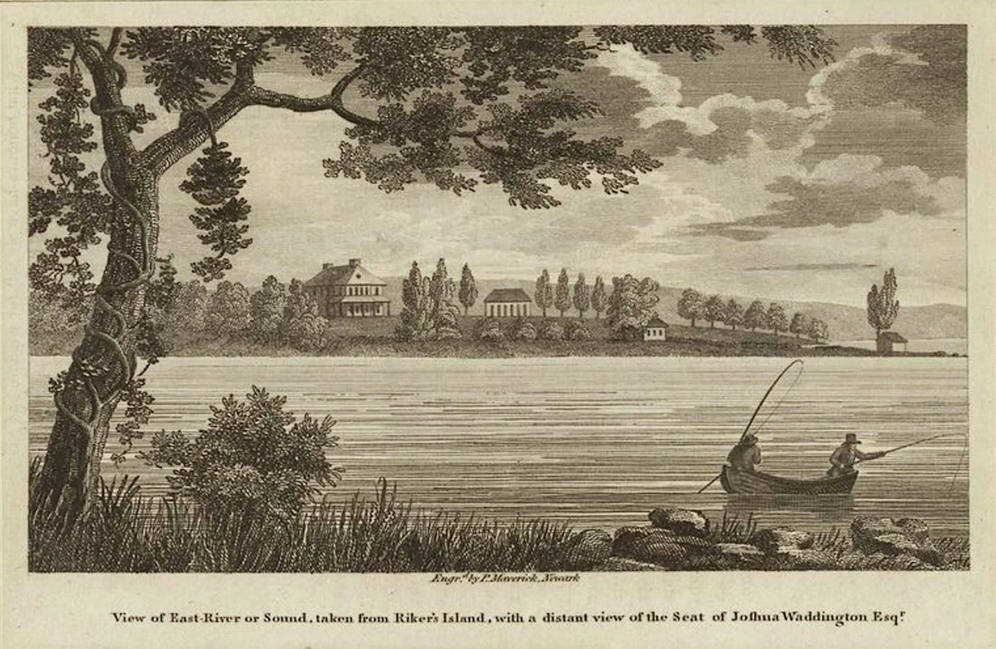
View of the East River from Riker’s Island (engraving), ca. 1810–1815/ca. 1825.
Before Rikers Island became synonymous with incarceration, it was a farm.
For more than two centuries, the island was tied to the agricultural world of northern Queens: Bowery Bay, the Poor Bowery, Astoria, the East River, and the old family estates of Newtown. It was a place of fields, livestock, shoreline work, family inheritance, and river traffic.
Its later identity as a jail complex has been so overwhelming that the earlier history is often forgotten. Yet the island’s name comes from one of the oldest families in western Queens, and its story reveals how dramatically New York City can transform a landscape.
Rikers Island did not begin as an institution. It began as part of a colonial farm country.
An island in the East River
Rikers Island lies in the East River between Queens and the Bronx, near the waters of Bowery Bay and the western approach to Long Island Sound.
In the colonial era, it was smaller and more rural than the modern island. Its shoreline was shaped by tides, marshes, and the difficult currents of the nearby Hell Gate passage. The island was connected economically to the Queens shore, especially the old Poor Bowery district and the farms near Bowery Bay.[1][2]
The waters around the island were part of a larger Indigenous landscape long before European settlement. Older local histories recorded shell heaps, burial places, and other signs of Indigenous life in the Bowery Bay region, but they often treated this evidence as a vanished past rather than as the record of people displaced by colonization.[1][2]
The island itself was known in early records by different names. Kelsey stated that it had once been called Hewlett’s Island, after an earlier occupant, before it became associated with the Riker family.[1]
The name that survived was Rikers Island.
Abraham Rycken and the Riker family
The island’s history is tied to Abraham Rycken, or de Rycke, one of the earliest colonial landholders in the region.
Rycken is believed to have come to America by the late 1630s. He held land in the Wallabout area of Brooklyn and later acquired a grant at the Poor Bowery in northern Queens. He also obtained the island that became known as Rikers Island.[1]
The family name changed in spelling over generations. Rycken became Riker, and the family became one of the most prominent in Newtown and western Queens.
The Rikers were not simply island owners. They held farms, participated in local churches, intermarried with other old Queens families, and became part of the social and economic structure of colonial Long Island.[1]
By the late seventeenth and eighteenth centuries, the island had become part of a larger family estate system that included property around Bowery Bay and the Poor Bowery. The island’s value came from agriculture, water access, and its relationship to the mainland farms of Queens.
The Poor Bowery connection
Rikers Island was closely linked to the Poor Bowery, the agricultural district around Bowery Bay.
The Poor Bowery had begun as a Dutch Reformed Church poor farm. In 1656, Peter Luyster purchased much of the property, and the surrounding land later passed through the hands of families including the Rikers, Rapelyes, Moores, Lawrences, Berrians, and Kouwenhovens.[1]
The island was part of this agricultural world.
It was not isolated in the modern sense. Small boats connected it with the Queens shore. Family members, farm workers, supplies, livestock, and produce could move across the surrounding water. The island’s relationship with the mainland was practical and daily.
Kelsey described the Riker family as retaining substantial connections to the Poor Bowery estate and to religious life in Newtown. The family’s history demonstrates how islands in the East River were often extensions of mainland farms rather than separate worlds.[1]
Farming and family inheritance
Like many colonial estates, Rikers Island passed through inheritance.
After Abraham Rycken’s death in 1689, his son Abraham inherited the estate and later transmitted it to his own sons. The island remained within the family for generations, part of the long continuity that gave the Riker name such local importance.[1]
The estate was agricultural. The island’s open land could support farming, grazing, and related uses. Its shore offered access to fishing and water transport. The surrounding waterways connected it to Newtown, Bowery Bay, Astoria, Manhattan, and the wider harbor.
The Riker family’s ownership also placed the island within the social world of colonial Queens. The family was associated with the Dutch Reformed Church, local offices, farm estates, and the extended network of old Long Island families.
For generations, Rikers Island was therefore part of the ordinary life of rural Queens.
That is the fact most obscured by its later institutional history.
Revolution and the East River
The island stood near waters of major military importance during the American Revolution.
Hell Gate, the East River, and the channels around the island were strategically significant. British forces occupied Newtown from 1776 to 1783. Military vessels moved through nearby waterways, and the Queens shore became part of the larger British-held zone around New York City.[1]
The island’s specific wartime role is less documented in the available local histories than the experience of nearby estates. But its location placed it within a contested maritime landscape. The East River was not simply scenery. It was a military route, a commercial artery, and a line of control between Manhattan and Long Island.
The same strategic geography that mattered in the Revolution would later make the island attractive to city authorities seeking a location for large public institutions.
From farm island to public institution
The transition from family estate to public institution came gradually.
As New York City expanded, its authorities increasingly looked to islands beyond Manhattan for uses that required space, separation, and control. Hospitals, almshouses, penitentiaries, workhouses, and other institutions were often placed on islands or distant shorelines.
Rikers Island became part of this pattern.
The island’s rural character made it attractive for institutional use. It was close enough to Manhattan and Queens to be accessible by water, but far enough from dense residential districts to seem separate. Its surrounding waters created a physical and symbolic boundary.
Over time, the agricultural landscape gave way to municipal control, institutional construction, and the uses for which Rikers Island later became known.
The shift was not unique. Nearby Blackwell’s Island, now Roosevelt Island, underwent a similar transformation from private estate to institutional landscape. The East River islands became places where New York City located functions it preferred to keep at a distance from everyday urban life.
Why the older history matters
Rikers Island is rightly associated with the immense human consequences of incarceration. But its deeper history matters because it shows that the island was not always defined by confinement.
It was once a farm island connected to Bowery Bay and the Poor Bowery. It was part of the Riker family’s estate system. It belonged to a landscape of water, fields, roads, mills, and family farms that stretched across northern Queens.
Understanding that earlier history does not erase the island’s modern significance. It provides context.
The island’s transformation from family farm to public institution is part of a broader story about New York City: how rural land was absorbed into the metropolis; how waterways became boundaries; how private estates became public facilities; and how places once defined by agriculture were remade for the institutions of a growing city.
Rikers Island has had more than one history. The jail complex is only the latest and most visible chapter.
Endnotes
Image
“View of East River or Sound, taken from Riker’s Island, with a Distant View of Joshua Waddington, Esq.” Engraving by Peter Maverick, ca. 1810–1815 (ca. 1825), Museum of the City of New York, accession no. 29.100.1975, unique ID MNY10461 (public domain / open access).
Literary
This article draws primarily on J. S. Kelsey, History of Long Island City, New York (1896), especially its discussion of Abraham Rycken, the Riker family, Hewlett’s Island, the Poor Bowery, Bowery Bay, and the colonial estate landscape of northern Queens. Eugene L. Armbruster, Long Island: Its Early Days and Development (1914), provides additional context for the Poor Bowery, Rikers Island, and Newtown’s early land grants. Both are valuable period histories but should be read critically, particularly in their treatment of Indigenous peoples, place names, colonial land transfers, slavery, and race.[1][2]