Hell Gate and Hallett’s Point
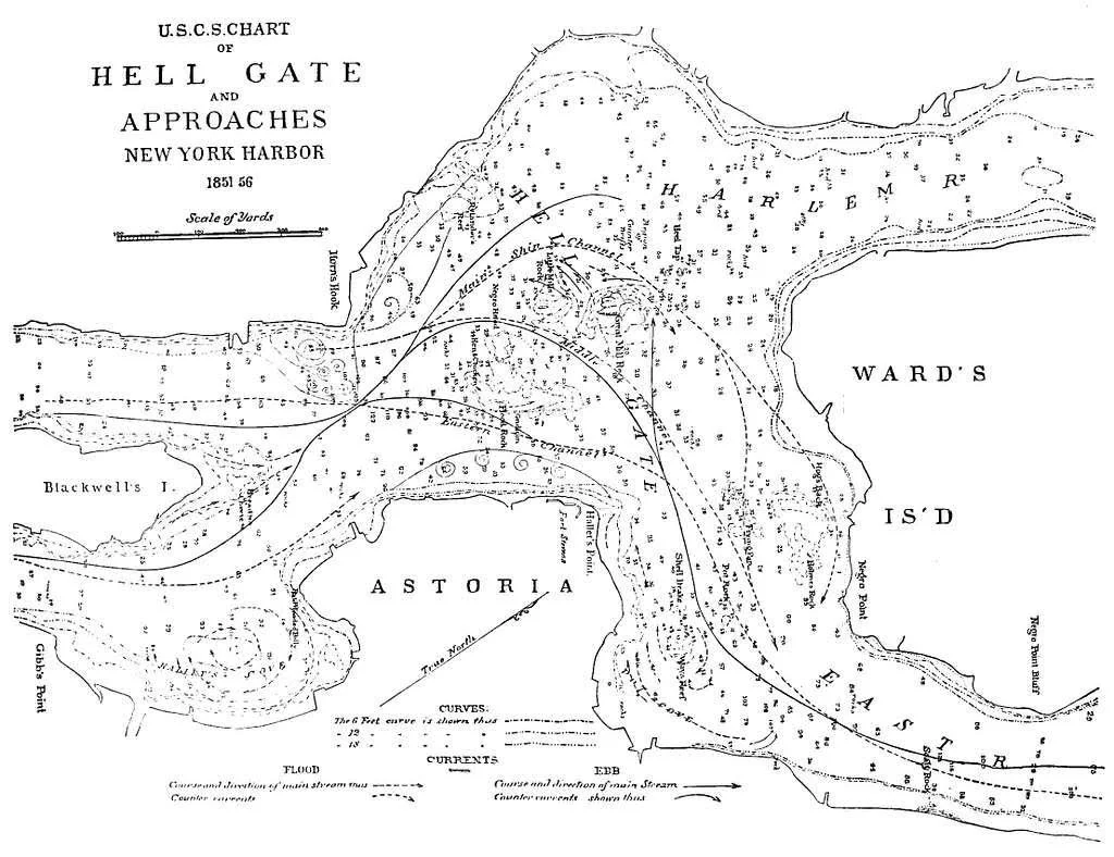
Map of Hell Gate, New York, from an 1885–1886 historical publication.
The Dangerous Waterway That Shaped Astoria and Queens
Hell Gate was never a gateway in the welcoming sense.
For centuries, it was one of the most feared passages in the waters around New York: a narrow, turbulent channel where tides collided, currents reversed, rocks lurked beneath the surface, and ships could be wrecked in moments. To sailors, it was a place of calculation and danger. To the communities along its Queens shore, it was a source of livelihood, military importance, engineering ambition, and constant fascination.
The history of Hell Gate is inseparable from the history of Astoria, Ravenswood, Hallett’s Point, and Long Island City. The waterway shaped the shoreline before there was a city, and it continued to shape the area long after the land had been covered with streets, factories, ferry slips, and apartment houses.
In 1876, one of the most dramatic engineering events in nineteenth-century New York took place at Hallett’s Point: the controlled destruction of a vast underwater reef. It was a spectacle witnessed by thousands and a turning point in the effort to make New York’s waterways safer for navigation.
A treacherous channel
Hell Gate is the narrow passage where the East River meets the western approach to Long Island Sound. The waters here were shaped by tidal movement from several directions, creating swift currents, whirlpools, eddies, and dangerous conditions for vessels.
Early Dutch navigators recognized the difficulty of the channel. Adriaen Block, who sailed through the waters in 1614, used the name Hellegat. The term is often translated as “Hell Gate,” though its original Dutch meaning has been debated. It may have referred to a difficult strait, narrow passage, or hazardous opening rather than simply invoking hell in the modern English sense.[1][2]
Whatever the name’s exact origin, the danger was real.
The channel was obstructed by reefs and rocks with memorable names: the Gridiron, Way’s Reef, Bread and Cheese Reef, Pot Rock, Frying Pan Rock, and Hallett’s Point Reef. These hazards were particularly dangerous because they lay within one of the busiest maritime approaches to New York.[1]
By the nineteenth century, the expanding commercial life of New York made the problem urgent. Larger ships, greater freight traffic, and intensified coastal commerce demanded safer passage through Hell Gate.
Hallett’s Point and the riverfront
Hallett’s Point projected into the dangerous waters of Hell Gate from the Queens shore.
The point stood near Hallett’s Cove, the settlement that later became Astoria. Its shoreline, bluffs, and reefs made it a strategic place in both military and maritime history. The Queens shore opposite Manhattan offered views across the river, access to ferry routes, and proximity to the narrowest and most turbulent stretch of the East River.[1]
During the Revolutionary War, the area became part of the British military occupation of Newtown. British troops under General James Robertson were stationed near Hell Gate and exchanged fire with American forces on Manhattan’s Horn’s Hook. The military value of the location was obvious: whoever controlled the passage could monitor movement through one of New York’s critical waterways.[1]
During the War of 1812, local residents built a blockhouse near Hallett’s Cove. Later, Fort Stevens stood near the point, named for Major General Ebenezer Stevens, a Revolutionary War officer and veteran of the Boston Tea Party.[1]
The point was therefore more than a geographic feature. It was a place where the river, war, commerce, and settlement met.
The reefs that threatened New York
By the middle of the nineteenth century, the rocks of Hell Gate had become a national concern.
In 1848, U.S. Navy officers Charles H. Davis and David Porter surveyed the channel and identified the principal hazards. Their work drew attention to the need for systematic removal of the reefs that made navigation dangerous.[1]
Early efforts were limited. In 1851, a privately funded attempt used surface explosions of gunpowder. The explosions broke off some fragments, but they did not solve the larger problem. The rocks remained too dangerous, and the method was too crude.[1]
The New York Harbor Commission renewed interest in the project in 1856, but serious progress did not begin until Major General John Newton of the U.S. Army Corps of Engineers took charge in 1866. Newton approached the problem with patience, precision, and a willingness to attempt engineering on a scale that had rarely been seen in the United States.[1]
Congress appropriated funds for the work in 1868. Newton’s task was not simply to blast isolated rocks. It was to transform the channel.
General Newton’s plan
Newton’s most ambitious target was Hallett’s Point Reef.
The reef extended hundreds of feet into the East River and was one of the most dangerous obstructions in Hell Gate. Newton’s plan was extraordinary: rather than attack the rock only from above, engineers would undermine it.
Workers constructed a cofferdam and sank a shaft below the waterline. From there, they excavated a network of tunnels and galleries beneath the reef. The work involved thirty-five radiating tunnels and ten transverse galleries. In all, the underground system extended thousands of feet beneath the water.[1]
The figures convey the scale of the project:
The excavation covered more than two and a half acres.
The tunnels and galleries extended roughly 7,425 feet in total.
More than 47,000 cubic yards of rock and material were removed.
More than 13,500 cartridges of explosive were placed in 4,427 drilled holes.[1]
The engineering was difficult and dangerous. The work took place beneath a reef surrounded by powerful tidal currents. The tunnels had to be carefully planned, ventilated, and supplied. The explosives had to be distributed precisely enough to break the reef without producing uncontrolled destruction.
This was not merely a demolition job. It was a calculated act of subterranean engineering.
The blast of September 24, 1876
The final explosion occurred on Sunday afternoon, September 24, 1876.
Crowds gathered on the Queens shore and at vantage points throughout the region. Officials, engineers, residents, and curious spectators watched from bluffs, boats, islands, and nearby shoreline. The event had become a public spectacle: New York was about to destroy one of the most notorious obstacles in its harbor.[1]
At the appointed moment, General Newton’s young daughter pressed the electric key that triggered the blast.
The explosion was not a towering fireball. It was largely submerged and controlled. Kelsey described a deep, muffled report, a slight vibration of the earth, and a column of muddy water and rock fragments rising above the river.[1]
Then Hallett’s Point Reef was gone.
The blast broke the reef apart, and dredges later cleared the debris. The result was a channel with a depth of approximately twenty-six feet at low tide, a major improvement for vessels navigating Hell Gate.[1]
The event became one of the great engineering triumphs of nineteenth-century New York.
The larger Hell Gate project
The destruction of Hallett’s Point Reef was only one part of Newton’s broader work.
Other dangers were also attacked. Frying Pan Rock was reduced in 1872. Way’s Reef was lowered through blasting and drilling. Pot Rock and other obstructions were addressed through successive operations.[1]
The work continued beyond the 1876 blast. Later projects focused on Flood Rock, another major obstruction in the channel. Together, these efforts transformed Hell Gate from a feared maritime hazard into a more manageable commercial waterway.
The significance extended beyond local navigation. Hell Gate was a key passage between Long Island Sound, the East River, and New York Harbor. Safer navigation meant more reliable movement of freight, passengers, fuel, building materials, and industrial products through the metropolitan region.
For Astoria and Long Island City, this was especially important. Their waterfront industries depended on waterborne commerce. The improvement of Hell Gate strengthened the economic logic of development along the Queens shore.
Hell Gate and the making of modern Queens
The engineering work at Hell Gate altered more than the river.
It helped make the Astoria and Ravenswood waterfront more accessible to modern commerce. It encouraged industrial development. It supported ferry traffic and waterborne trade. It made the East River less a natural barrier than a transportation corridor.[1]
The same waters that had once isolated settlements also connected them. Hell Gate’s danger had made the Queens shore feel distant from Manhattan. Its improvement helped integrate western Queens more closely into the metropolitan economy.
The river remained powerful, however. The current did not disappear. The rocks were reduced, but the passage retained its reputation. Even today, Hell Gate is recognized as one of the most complex tidal environments in New York Harbor.
A landscape of memory
Hallett’s Point Reef no longer rises beneath the water as it once did. Fort Stevens is gone. The old blockhouse has disappeared. The rural shore of Hallett’s Cove has become part of a dense urban neighborhood.
Yet Hell Gate remains one of the great historical landscapes of Queens.
It explains why Astoria developed where it did. It explains why ferries mattered, why military forces watched the shoreline, why industrial works clustered nearby, and why engineers devoted years of labor to blasting the riverbed.
The name still carries its old force.
Hell Gate was not simply a frightening label on a map. It was a real obstacle that had to be understood, respected, and eventually remade by human engineering.
End Notes
Images:
Map of Hellgate - Internet Archive / Wikimedia Commons, via GetArchive, “PSM V28 D451 Hell gate new york,” 1885–1886. Public domain.