Jamaica Bay: Nature, Industry, and the Lost Edge of New York
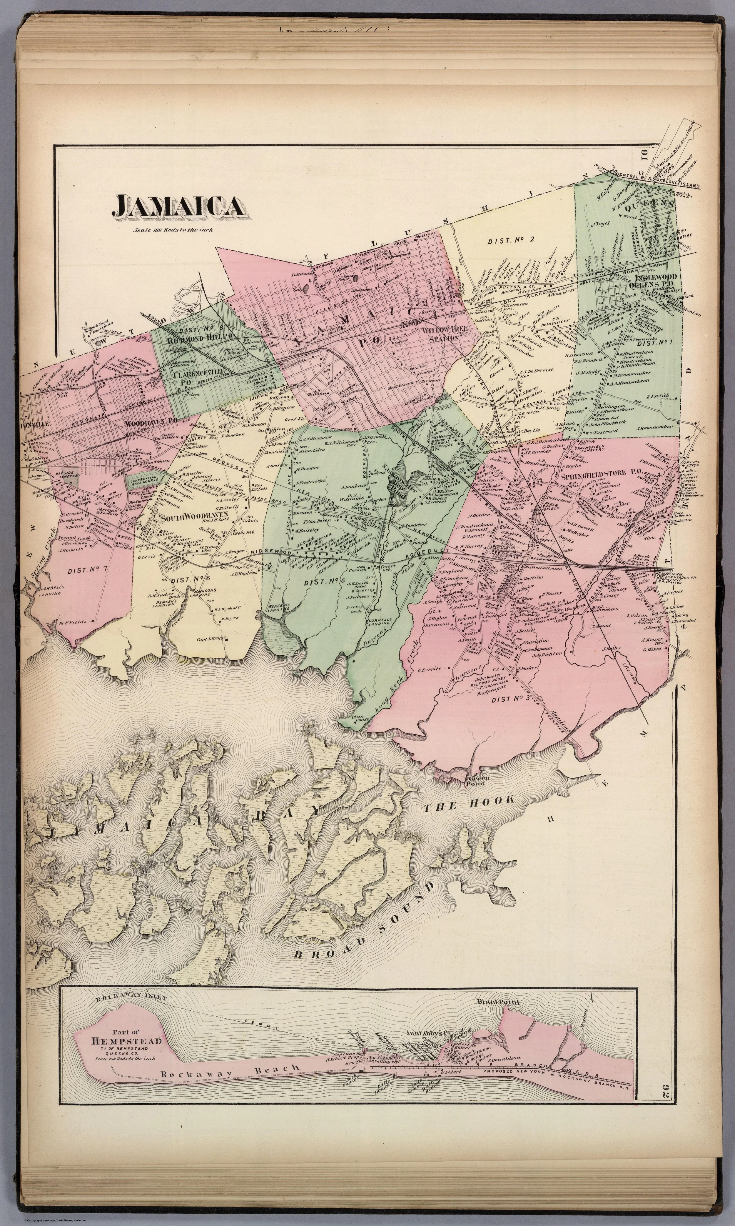
Map of Jamaica, Queens, 1873
A five-part series on the historical ecology, recreation, exploitation, and reinvention of one of New York’s most overlooked landscapes.
Jamaica Bay is often described as if it were a leftover.
From the window of a descending plane, from the margins of a parkway, or from the edge of a marsh trail, it can appear as one of those strange border landscapes the city never fully absorbed: open water, reeds, mud, channels, wind, and infrastructure. To many New Yorkers, it reads as a scenic interruption or an environmental problem. It is a place people pass over, drive around, restore in theory, and rarely think about historically.
But Jamaica Bay has a history as deep and consequential as many better-known parts of the city.
Long before it became associated with airport approaches, resilience planning, or urban wilderness, it was a productive estuary that sustained communities for generations. Its waters yielded oysters, clams, fish, and industrial raw material. Its shorelines and islands supported settlement, labor, and small-scale maritime economies. In the nineteenth century, it also became a landscape of leisure, drawing anglers, boaters, hunters, hotel guests, and bungalow dwellers to the city’s edge. Later, as New York expanded, the bay was increasingly burdened with the costs of metropolitan growth: dredging, filling, pollution, waste, industrial use, and planning schemes that treated wetlands less as living systems than as convenient blank space.
That long transformation is the subject of this series.
These five essays trace Jamaica Bay from abundance to recreation, from prosperity to contamination, and from environmental sacrifice to contemporary restoration. They argue that the bay is not merely a natural feature at the edge of New York, but one of the places where the city worked out its relationship to food, transport, leisure, waste, expansion, and ecological damage. To understand Jamaica Bay is to understand something essential about how New York has historically used landscapes it considered peripheral, and how those supposedly peripheral places often proved central after all.
The story of Jamaica Bay is not simply the story of environmental decline. It is also the story of forgetting.
Modern discussions of the bay often frame it as habitat, risk zone, or public land, all of which it is. But those framings can obscure the fact that Jamaica Bay was once a human landscape as well: inhabited, worked, visited, argued over, exploited, and depended upon. What makes the bay so compelling is precisely that it has been many things at once — estuary, fishery, resort, industrial edge, transportation corridor, planning problem, and restoration landscape. Its history resists simple categories because New York itself has never known how to treat places like this except by using them heavily and remembering them poorly.
This series begins with the bay as a source of food and livelihood, then moves into its age of recreation, its oyster economy and collapse, its descent into a sacrifice zone, and finally its modern status as a place of restoration and climate concern. Taken together, these essays attempt to recover Jamaica Bay not as scenery, but as history.
If you want to understand how New York expands, what it chooses to value, and what it prefers to forget, Jamaica Bay is one of the best places to look.
Series Index
Part I
Jamaica Bay Before The Airports
Before pollution, dredging, and modern neglect, Jamaica Bay was one of the region’s productive estuaries, sustaining fisheries, shellfishing, and local economies for generations.
Part II
When Jamaica Bay Was New York’s Waterside Playground
In the late nineteenth century, the bay became one of the metropolitan region’s early recreational frontiers, drawing anglers, hunters, boaters, and summer visitors to its marshes and shorelines.
Part III
The Rise and Ruin of Jamaica Bay Oysters
The oyster beds of Jamaica Bay helped define its economy, but disease, pollution, and urban growth turned one of the bay’s great natural assets into a public-health hazard.
Part IV
The Smell of Progress: How Jamaica Bay Became a Dumping Ground
As New York expanded, the bay’s edges absorbed the refuse, industrial uses, and environmental burdens that the growing city preferred to push out of sight.
Part V
Jamaica Bay After History: Restoration, Memory, and the Future of the Urban Estuary
Today Jamaica Bay is framed through resilience, restoration, and climate adaptation — but its future makes the most sense when read alongside its forgotten history.
End Notes
Map of Jamaica, Queens - F.W. Beers, “Jamaica (New York),” with inset “Part of Hempstead, Tn. of Hempstead, Queens Co,” in Atlas of Long Island, New York. From Recent And Actual Surveys And Records Under the Superintendence of F.W. Beers (New York: Beers, Comstock & Cline, 1873), hand-colored map, David Rumsey Map Collection, https://www.davidrumsey.com/luna/servlet/detail/RUMSEY812174275503600:Jamaica--Long-Island-.