Ravenswood: The Lost Estates and Industrial Shoreline of Western Queens
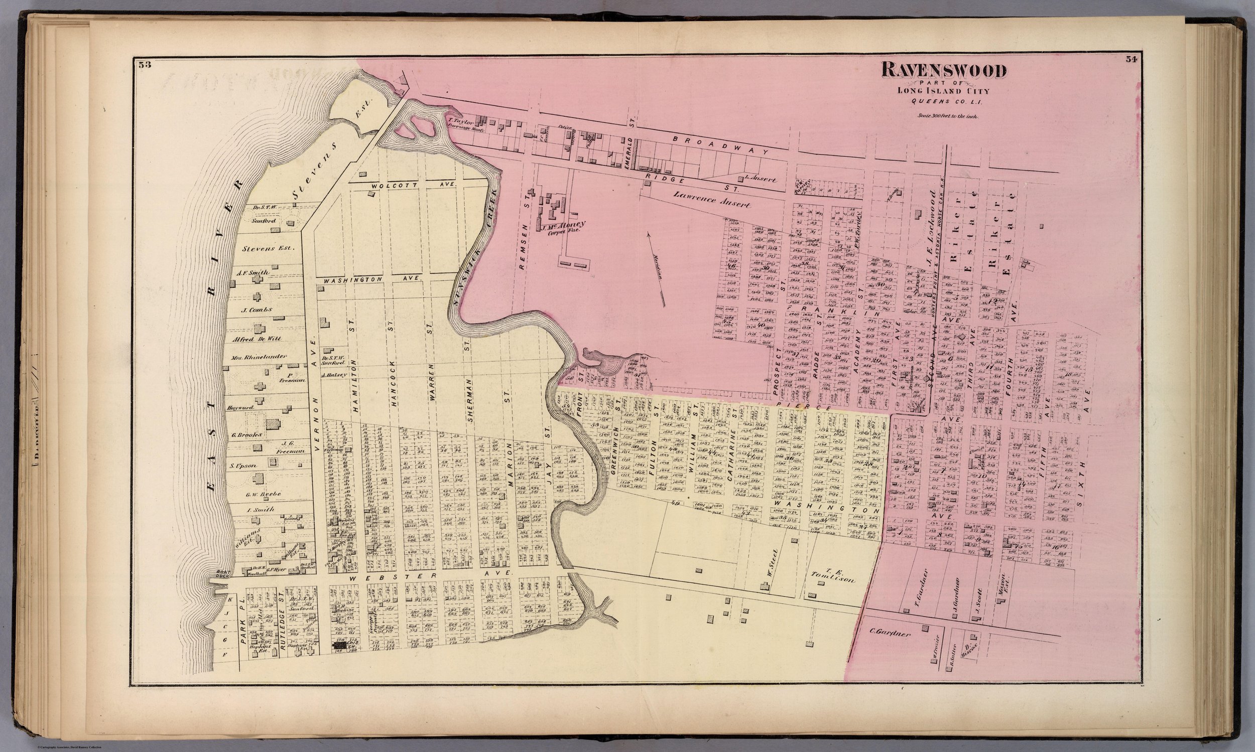
Ravenswood, Long Island City, by F.W. Beers, 1873. David Rumsey Map Collection.[10]
Ravenswood is one of the most evocative names in Queens history. It suggests wooded bluffs, river winds, and old country houses -- but the neighborhood’s past also includes colonial patents, Revolutionary occupation, a municipal poor farm, immigrant quarantine, gas works, tunnels, and factories.
The old Ravenswood landscape stretched along the East River between Astoria and Hunter’s Point. It was part of the northwestern “Out Plantations” of Newtown, a waterfront countryside that lay close to Manhattan but remained rural for generations. Its history was shaped by the same forces that transformed all of western Queens: water, land, transportation, industry, and the relentless pressure of New York City’s expansion.
Before Ravenswood had a name
The ground later called Ravenswood was not originally a village. It was a collection of waterfront grants and estates along the East River.
The earliest European landholder identified in nineteenth-century histories was Captain Francis Fyn, who received a substantial Dutch grant along the river in 1651. After the English conquest of New Netherland in 1664, title to the land appears to have shifted to Jacob Blackwell, whose family became central to the history of the area.[1]
The Blackwell name was already deeply connected to the geography of the East River. Richard Blackwell, Jacob’s father, had married into the family connected with Blackwell’s Island—today Roosevelt Islan -- and the family’s holdings extended across the water as well as along the Long Island shore. Jacob Blackwell’s house, built near the foot of what later became Webster Avenue, was remembered in nineteenth-century accounts as one of the oldest surviving mansions in the area.[1]
The riverfront was valuable because it faced Manhattan, but it was also difficult. Hell Gate’s currents, rocks, and tidal turbulence made the nearby waters dangerous. The neighborhood’s dramatic shoreline was a source of beauty and commerce, but it was never a placid suburban edge.
From “Waterside” to Ravenswood
Ravenswood had more than one name before the modern one took hold.
Early histories refer to the locality as Waterside, a straightforward description of a settlement along the East River. Later it was briefly called Matona, though that name did not endure. The enduring name, Ravenswood, was attributed to the Rev. Francis L. Hawks, an Episcopal clergyman and prominent nineteenth-century writer.[1]
According to the account preserved by Kelsey, Hawks first proposed “Ravenscroft” in honor of his friend, Bishop John Stark Ravenscroft of North Carolina. When it was suggested that the smallness of the place might make the compliment seem inadequate, Hawks chose “Ravenswood” instead. Later explanations proposed that the name referred either to the large number of crows in the district or to Sir Walter Scott’s The Bride of Lammermoor, in which Ravenswood is a memorable name.[1]
Whatever the precise origin, Ravenswood was a name that recast a working waterfront and farm country in romantic terms. It evoked landscape and literature, not mills, roads, or land titles. That was fitting for a district that, during the nineteenth century, became associated with country estates and river views.
The Blackwell estate and the Revolutionary War
The Blackwell family’s estate stood at the center of Ravenswood’s colonial history. By the Revolutionary era, it was a place of consequence -- not merely a farm, but a strategically placed riverside property near Hell Gate and Manhattan.
When British forces occupied Newtown during the Revolution, local estates became vulnerable to confiscation, occupation, and use as military headquarters. Kelsey reported that Colonel Jacob Blackwell, a veteran of the French and Indian War and a supporter of the patriot cause, fled to Hopewell, New Jersey, when British troops invaded. His home near the foot of later Webster Avenue was confiscated and marked with the “Broad Arrow,” the British symbol of Crown property.[1]
When Blackwell returned in 1780, he reportedly found his house still occupied by British officers. The story captures the upheaval faced by many Queens families during the war. Political allegiance had immediate consequences: property could be seized, households displaced, and familiar homes absorbed into the machinery of occupation.[1]
The Revolution also made the nearby waterfront an active military zone. British troops occupied positions at Hallett’s Cove, ships used Newtown Creek, and the turbulent waters of Hell Gate remained strategically important. Ravenswood stood within sight of Manhattan but on the wrong side of a river controlled by imperial power.
A country retreat beside the city
After the Revolution, Ravenswood resumed its character as a district of farms and country estates.
The old waterfront homes were among the most admired in western Queens. In 1792, John Delafield built a mansion known as Sunswick at Ravenswood. The Blackwell homestead remained a notable landmark, while nearby estates preserved the memory of the old agricultural and mercantile families that had shaped the northern East River shore.[1]
By the nineteenth century, the riverfront from Astoria southward had become attractive to wealthy New Yorkers seeking country homes near the city. The appeal was practical as much as picturesque. The East River provided access to Manhattan, while the Queens shore offered open space, gardens, larger houses, and relief from the density of the city.
Ravenswood therefore shared in the broader suburban transformation of Astoria. Its old estates were part of a landscape that later observers remembered as unusually beautiful: a shoreline of large homes, mature trees, broad lawns, and unobstructed river views.[1]
But the same access that made Ravenswood desirable to country residents also made it attractive to institutions and industry.
The Ravenswood Poor Farm
One of the most striking episodes in Ravenswood history was the establishment of a Poor Farm by the City of New York.
Around 1834, New York City erected buildings in Ravenswood for the care of the poor. The site stood on the Queens shore, physically separate from Manhattan but close enough to be accessible by water. The use of outer districts for institutions that Manhattan did not wish to house within its own boundaries was a familiar pattern in nineteenth-century metropolitan history.[1]
The Poor Farm buildings were later sold after public institutions were relocated to islands in the East River. The buildings were then leased to the Commission of Emigration for use connected with a ship-fever hospital and related purposes. Such facilities provoked local alarm and resistance. Kelsey’s account states that, after repeated protests failed, local residents destroyed the buildings.[1]
The episode illustrates an enduring tension in the history of western Queens: the district was close enough to Manhattan to receive its institutions, but distant enough to be treated as expendable. Ravenswood’s waterfront was a desirable residential landscape -- and, at the same time, a place where city authorities could locate unpopular public functions.
Ferries, factories, and the industrial shore
By the mid-nineteenth century, Ravenswood was being drawn into the industrial economy of Long Island City.
Transportation improved. Roads and stage routes connected the district with Astoria and ferry crossings to Manhattan. Factories and stone yards began to change the waterfront. The quiet country shore was becoming an extension of the industrial metropolis.[1][1]
The most dramatic example came with the East River Gas Company. In the 1890s, the company constructed a tunnel beneath the East River from Ravenswood to Manhattan. The undertaking was an engineering achievement of its era. Shafts were sunk on both shores, headings were driven through difficult geological conditions, and compressed air was used where soft rock and water created hazards.[1]
On July 11, 1894, the headings met. The project created a passage beneath the East River for a thirty-six-inch gas main supplying Manhattan. The final alignment was remarkably precise: according to Kelsey, the headings met only about half an inch off direction.[1]
The tunnel changed Ravenswood’s meaning. The neighborhood was no longer merely connected to Manhattan by ferry and river traffic. It became physically linked beneath the river through modern engineering.
At the same time, gas production and other industries altered the shoreline. The East River Gas Company’s enormous gas holder became one of the best-known industrial landmarks in the district. At full height, Kelsey wrote, it rose 240 feet and held five million cubic feet of gas.[1]
The pastoral Ravenswood of old estates and wooded banks had entered the age of industrial infrastructure.
Ravenswood joins Long Island City
In 1870, Ravenswood became part of Long Island City, along with Astoria, Hunter’s Point, Dutch Kills, Blissville, Middletown, Steinway, and Bowery Bay.
The merger brought Ravenswood into a new municipal system organized around the needs of a growing waterfront city. The first Long Island City election reflected Ravenswood’s role in the new government: George Parsells of Ravenswood was elected recorder, while Anthony S. Woods of Ravenswood became city marshal.[1]
The consolidation did not erase local identity. Ravenswood remained distinct from Astoria to the north and Hunter’s Point to the south. But it became increasingly tied to the industrial and transportation systems that defined Long Island City.
By the end of the nineteenth century, the neighborhood contained traces of several different eras at once: old estates, churches, ferry routes, industrial works, waterfront yards, and modern utility infrastructure. That mixture was Ravenswood’s historical character.
What survives of Ravenswood?
Much of historic Ravenswood has vanished. The old country estates were subdivided, altered, or demolished. The waterfront was transformed by bulkheads, power facilities, industrial structures, and later redevelopment. The Poor Farm buildings are gone. The old roads have become urban corridors.
Yet Ravenswood still survives as a historical idea and a geographic memory.
Its name preserves the nineteenth-century vision of a wooded riverfront retreat. Its streets preserve the traces of older estates and village boundaries. Its industrial history remains visible in the scale of the waterfront and in the enduring importance of utilities, transportation, and infrastructure along the East River.
Ravenswood was never only one thing. It was a colonial grant, a family estate district, a Revolutionary landscape, a place of institutions, a nineteenth-century suburb, an industrial shore, and a component of Long Island City.
That layered history is precisely what makes it one of the most compelling of Queens’s lost neighborhoods.
End Note
[10] "Ravenswood, Part of Long Island City, Queens Co., L.I.," by F.W. Beers, published by Beers, Comstock & Cline, 1873, in Atlas of Long Island, New York, from Recent and Actual Surveys and Records under the Superintendence of F.W. Beers (New York, 1873). From the David Rumsey Map Collection, David Rumsey Map Center, Stanford University Libraries. Accessed via: David Rumsey/ Map of Ravenswood