Dutch Kills: The Creek, Mills, and Farms Beneath Modern Long Island City
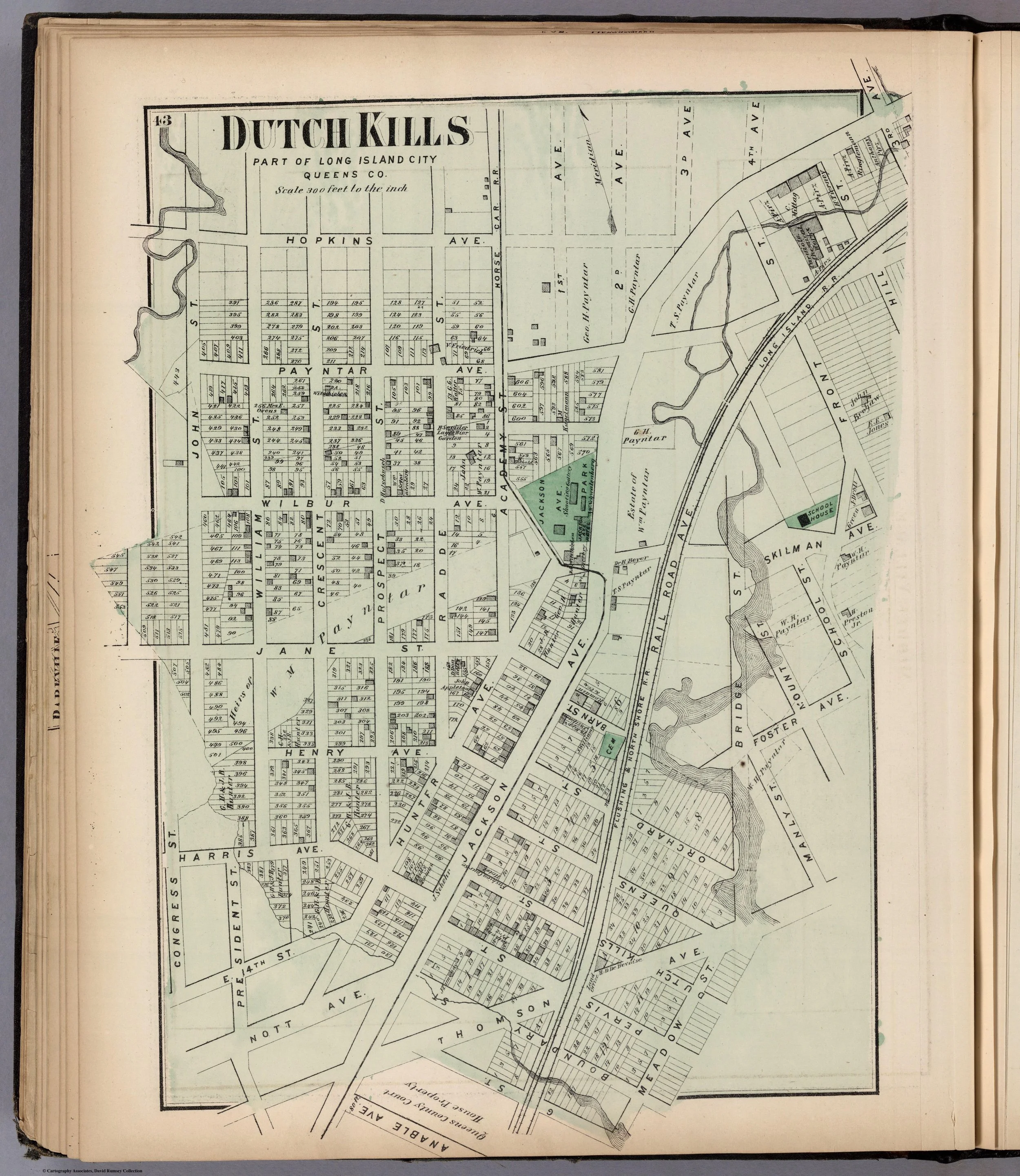
Dutch Kills, Long Island City, by F.W. Beers, 1873. David Rumsey Map Collection.[8]
Dutch Kills was once a watery inland world: a place of tidal creeks, mill wheels, farm lanes, orchards, and family homesteads. Today, much of its original landscape lies hidden beneath streets, rail lines, warehouses, apartment buildings, and the built fabric of Long Island City.
Its name preserves the older terrain. A kill is a creek, and Dutch Kills was shaped by the stream that early records called Canapaukah or Canapaukah Creek. Flowing through the lowlands of western Newtown, the creek connected farms and mills with Newtown Creek, the East River, and Manhattan beyond.
The history of Dutch Kills is not the story of a single formal village. It is the story of a waterway around which settlers claimed land, built mills, established farms, and created a community that endured long after its rural setting had begun to vanish.
A creek before a neighborhood
The Dutch Kills area lay within the northwestern part of the old Town of Newtown, a district later remembered as the “Out Plantations.” The term described scattered farms and holdings beyond the settled center of Newtown village.
The creek at the heart of the neighborhood was known in colonial records by variations of Canapaukah. Later writers called it Dutch Kills Creek. It was tidal, navigable in portions, and economically valuable. Produce from inland farms could move toward the East River, while tidal conditions supported small-scale milling and other commercial activity.[1][1]
Before colonial settlement, this was part of an Indigenous landscape. Nineteenth- and early twentieth-century local histories recorded Indigenous place names, shell heaps, and evidence of long habitation, but their broad conclusions about tribal territories and language should be handled with care. What is certain is that Dutch and English settlers entered a lived-in landscape, not an empty wilderness.[1][1]
The creek was both a route and a boundary. It divided early grants, directed local travel, and linked households that might otherwise have been separated by marshland and woodland.
Three early settlers
The earliest colonial history of Dutch Kills revolves around a small group of seventeenth-century settlers whose land grants created the framework of the later community.
Richard Brutnall, an Englishman from Bradford, settled on the east side of Canapaukah Creek. His holding of more than one hundred acres was confirmed by Governor William Kieft on July 3, 1643.[1]
On the west side of the creek, Tymen Jansen, a ship carpenter employed by the Dutch West India Company, established another plantation. His land later came into the possession of Joris Stevensen de Caper, and from that connection emerged the Van Alst family’s long association with the area.[1]
A third early settler, Burger Jorissen, settled north of Jansen. Jorissen, described by Kelsey as a Silesian immigrant, received his ground brief in July 1643. He was credited with establishing a gristmill at tidewater before 1654. The stream was thereafter sometimes called Burger’s Kill—a reminder that in colonial Queens, a mill could name a waterway as effectively as a mapmaker.[1]
The settlement was never exclusively Dutch. Dutch government, English migration, German-speaking settlers, Scandinavian connections, and intermarrying families all contributed to the district’s social landscape. Dutch Kills became what much of colonial Queens was: a mixed community shaped less by rigid national identity than by land, water, kinship, labor, and changing political power.
Mills, fields, and the Van Alst family
For generations, Dutch Kills remained a farming country.
Its creek carried produce toward the East River. Its tidal flow supported milling. Its fields were divided among families whose names continued to appear in local land records and nineteenth-century histories: Van Alst, Payntar, Bragaw, Riker, Rapelye, Suydam, and others.
The Van Alst family became especially identified with the district. Kelsey traced their local lineage to George Van Alst, remembered as “the sailor,” who was said to have emigrated from West Flanders and settled along Canapaukah in the seventeenth century. Whether every detail of that family tradition can be independently verified, the larger fact is beyond dispute: the Van Alsts were among the major landholding families in Dutch Kills for generations.[1]
Their most visible monument was the Van Alst mansion, built in 1766. By the late nineteenth century, it stood in increasingly isolated grandeur near Jackson Avenue, above Jane Street, surrounded no longer by open farmland but by the advancing city. Kelsey described the house as deteriorating under neglect and vandalism, its old brass knocker gone and its historic fabric steadily disappearing.[1]
The mansion mattered because it embodied the old order. Dutch Kills had once been a landscape of family farms, where the distance between homesteads, fields, and creek land made the neighborhood feel rural even while Manhattan stood only a short distance away by water.
A landscape already altered
The old local histories often describe Dutch Kills as though settlers encountered land conveniently prepared for European agriculture. Kelsey, for example, suggested that Indigenous land management had left sections of the country comparatively open for planting and pasture. That observation contains an important corrective to the old “wilderness” myth, but the nineteenth-century language surrounding it must be read critically.
European settlement was not a peaceful improvement of vacant ground. It occurred through colonial authority, unequal land transactions, displacement, and the gradual destruction of Indigenous control over the land and waterways. The farms of Dutch Kills were built within that larger history.[1][1]
By the eighteenth century, Dutch Kills had settled into an agricultural rhythm. Farms were often substantial but not enormous. Families raised crops, kept livestock, built fences, and relied on creeks and roads for trade. The neighborhood’s relationship to Manhattan was commercial from the beginning, even when its physical character remained rural.
The creek gave Dutch Kills an advantage, but it also made the district vulnerable to the changes that came with industrialization. Waterways that had once served farms and mills later attracted factories, rail lines, dumping, filling operations, and dense urban development.
Revolution and occupation
Like the rest of Newtown, Dutch Kills was drawn into the American Revolution through British occupation.
The Town of Newtown was occupied by British forces from 1776 until the end of the war in 1783. Newtown Creek served as a sheltered route and refuge for British vessels. The roads and farm districts around Dutch Kills were part of a military landscape in which private homes, barns, fields, and waterways could be commandeered or damaged by troops.[1]
The period left a deep impression on local memory. Nineteenth-century accounts emphasized British and Hessian occupation, the use of houses as headquarters or billets, and the plundering of farm property. Such stories varied in their detail and reliability, but the larger fact is clear: the Revolution disrupted the agricultural communities of western Queens and brought the violence of imperial conflict into their daily life.[1]
After the war, the farms endured. But the metropolitan world around them was changing rapidly.
From farm district to city neighborhood
The nineteenth century transformed Dutch Kills more gradually than it transformed Hunter’s Point, but the effects were profound.
Hunter’s Point, at the mouth of Newtown Creek, became a railroad and ferry terminus. Astoria developed as a prosperous riverside village. Newtown Creek became increasingly industrial. Roads and turnpikes improved, and land that had once been valued primarily for farming began to acquire suburban and industrial value.[1]
Jackson Avenue became one of the great corridors of this new urban geography. It connected the growing Hunter’s Point district with Flushing and the inland communities of Queens. The old Van Alst estate, once surrounded by fields, stood near an increasingly important route into Long Island City.[1]
Railroads further changed the neighborhood’s relationship to the wider region. The Flushing Railroad’s arrival at Hunter’s Point in 1854 and the Long Island Rail Road’s move of its western terminus to Hunter’s Point in 1861 concentrated movement, labor, and investment in the lower part of western Queens. Dutch Kills was no longer a distant interior farming district. It was becoming part of the approach to a new transportation city.[1]
The process was not always orderly. Streets had to be opened and graded. Watercourses had to be bridged, redirected, or filled. The old creek system, once an asset, became increasingly difficult to reconcile with the grid of a growing city.
Dutch Kills enters Long Island City
In 1870, Dutch Kills became part of the newly incorporated City of Long Island City, along with Astoria, Hunter’s Point, Ravenswood, Blissville, Middletown, Steinway, and Bowery Bay.
The new municipal government was intended to address the infrastructure problems of the expanding communities of western Newtown. Its work included streets, water supply, schools, police and fire protection, drainage, taxation, transit, and the difficult task of imposing a unified civic structure on places that had developed separately for generations.[1]
Dutch Kills occupied an important middle ground in the new city. It was neither purely waterfront nor entirely inland. It linked Hunter’s Point and the industrial lower wards with Astoria, Woodside, Sunnyside, and the older roads to Flushing and Newtown. The creek that had once defined the neighborhood’s agricultural life now became one element in a rapidly urbanizing landscape.
By the end of the nineteenth century, Dutch Kills had become increasingly associated with railroads, factories, working-class housing, and the infrastructure of Long Island City. Yet the older neighborhood remained present in names, family records, surviving houses, and the enduring course of the creek itself.
The hidden waterway
Dutch Kills today is easy to overlook because much of its original geography has been obscured. Its creek is constrained, altered, and largely invisible from the street. Its old farmhouses have mostly disappeared. The broad agricultural landscape that once surrounded the Van Alst mansion and Burger Jorissen’s mill is gone.
But the neighborhood’s name still tells the story.
A “kill” was a creek. Dutch Kills was a creek community before it was a city neighborhood. Its first economy depended on water movement, milling, and farming. Its later history depended on transportation, manufacturing, land development, and municipal consolidation.
The transition from creek to corridor—from tidewater mill country to urban Queens -- makes Dutch Kills one of the most revealing historical landscapes in Long Island City.
End Notes
[8] "Dutch Kills, Part of Long Island City, Queens Co.," by F.W. Beers, published by Beers, Comstock & Cline, 1873, in Atlas of Long Island, New York, from Recent and Actual Surveys and Records under the Superintendence of F.W. Beers (New York, 1873). From the David Rumsey Map Collection, David Rumsey Map Center, Stanford University Libraries. Accessed via: David Rumsey/ Map of Dutch KIlls