Astoria Before the Skyline
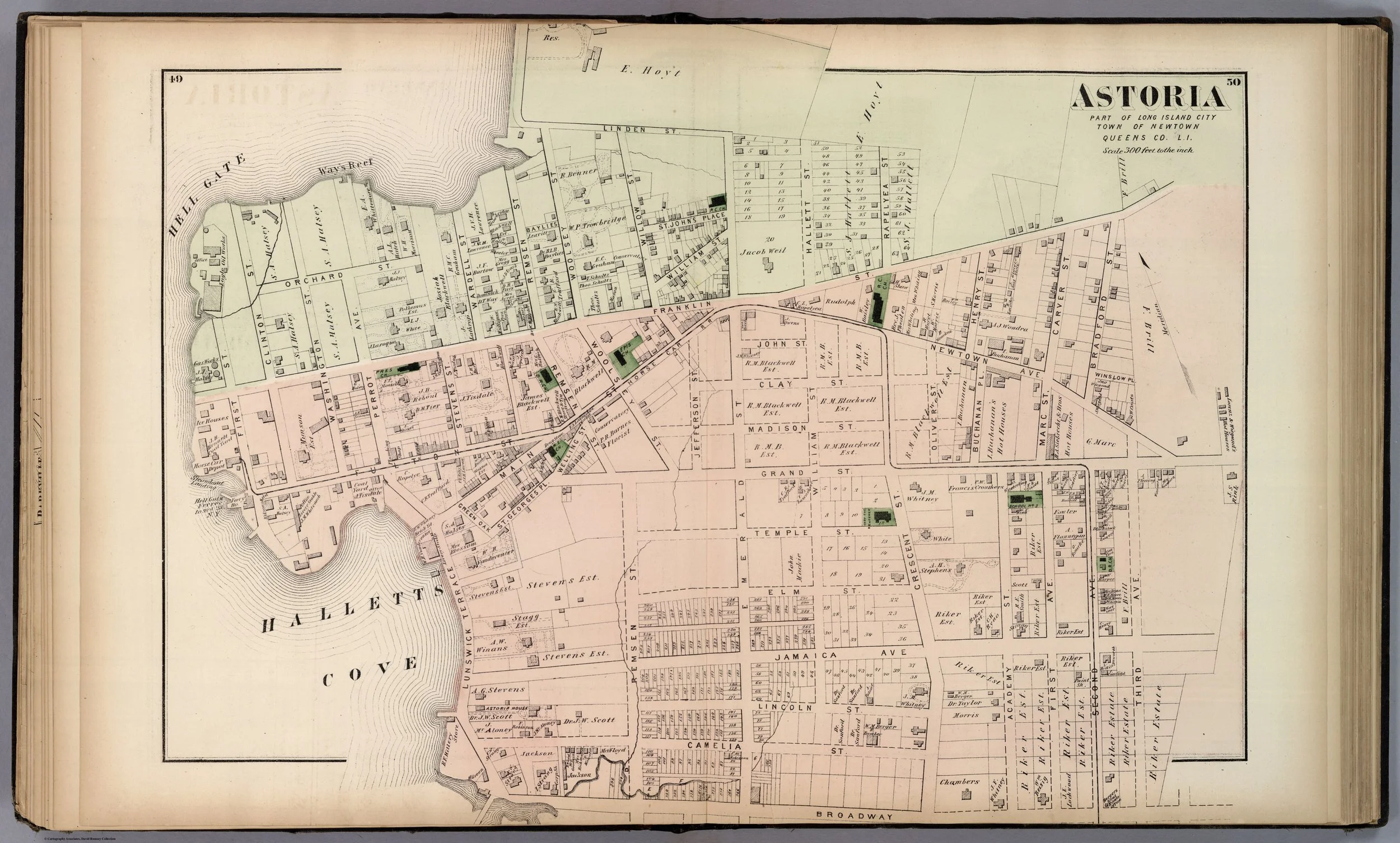
Middle Village, Newtown, & part of Astoria, by F.W. Beers, 1873. David Rumsey Map Collection.[7]
From Hallett’s Cove to a Queens waterfront village
Before apartment towers, subway platforms, film studios, and waterfront parks, Astoria was Hallett’s Cove -- a small, strategically placed settlement on the East River where farms, mills, ferries, and country estates confronted the violent waters of Hell Gate.
Its rise was not inevitable. Astoria emerged over more than two centuries from a mixture of colonial landholding, transportation, entrepreneurship, and proximity to Manhattan. The neighborhood’s history is written in names that remain on the map—Hallett’s Cove, Sunswick, Halsey Street, Ravenswood, and Astoria itself -- but much of the original landscape has disappeared beneath streets, rail lines, bulkheads, and buildings.
To understand Astoria, one must begin with the water.
A settlement at Hell Gate
The northern East River was never a quiet frontier. At Hell Gate, the tidal waters of Long Island Sound, the East River, and Harlem River produced a notoriously treacherous passage. Reefs, rocks, rapid currents, and shifting channels made navigation hazardous for centuries. Yet that same waterfront offered access to Manhattan, markets, fishing grounds, and the broader coastal trade of New York Harbor.
The land around modern Astoria was part of the northwestern reaches of the Town of Newtown, in Queens County. In the seventeenth century, this outlying district was often described as part of Newtown’s “Out Plantations”: scattered grants and farmsteads beyond the more concentrated village settlement inland.
The area was already part of an Indigenous landscape long before European colonization. Later nineteenth- and early twentieth-century local histories used Indigenous place names and discussed village sites, but their interpretations of tribal boundaries, language, and land transfer must be treated critically. What is beyond dispute is that European settlement proceeded through colonial grants and transactions imposed upon, or negotiated amid, a rapidly changing Indigenous world.[1][1]
In 1652, William Hallett—an Englishman with connections to New England settlement—received a grant from Dutch Director-General Peter Stuyvesant for approximately 160 acres extending from Sunswick Creek toward Berrian Island. His estate became the foundation of a community that would bear his name for nearly two hundred years: Hallett’s Cove.[1]
Hallett’s early experience was hardly tranquil. According to the nineteenth-century account of Long Island City historian J. S. Kelsey, an Indigenous attack destroyed his home and plantation, prompting a temporary retreat to Flushing before he returned to the cove. Whatever the precise circumstances, the episode reflects the instability of a colonial frontier where Dutch authority, English settlement, Indigenous sovereignty, and land speculation were all in conflict.[1]
Sunswick Creek and the working shore
The cove was never merely a picturesque shoreline. Its small waterways gave it practical value.
Sunswick Creek ran through the area and connected with the East River. In the colonial and early national periods, it could carry local products to market. Farmers used the creek system to move produce, while its tidal conditions made it suitable for milling. A lime kiln associated with the Hallett family may have been one of the earliest local industrial enterprises. Around a century after William Hallett’s original settlement, Joseph Hallett and Jacob Blackwell built a gristmill on Sunswick Creek; the mill later passed through other hands, including Hendrick Suydam during the Revolutionary era.[1]
The geography gave Astoria a dual identity that it has retained ever since. It was close enough to Manhattan to be commercially relevant, but spacious enough to remain agricultural, residential, and semi-rural well into the nineteenth century.
That balance made the neighborhood attractive to wealthy families seeking a retreat from the city. The East River gave them views and transportation. The uplands offered room for houses, gardens, orchards, and landscaped grounds. The very qualities that would later draw developers and industry first drew country gentlemen.
War on the waterfront
Astoria’s location ensured that it could not remain detached from the American Revolution.
Newtown was occupied by British forces from 1776 to 1783. Newtown Creek served as a haven for British vessels, while the Hell Gate shore became a military vantage point. Kelsey recounts that British troops under General James Robertson occupied the Hallett’s Cove area after mistakenly believing that General Charles Lee intended to land American troops nearby. Instead, the British used the position to exchange fire with American forces at Horn’s Hook on Manhattan.[1]
Five years later, Colonel John Connolly and the Royal Foresters wintered in the vicinity. A British officer, Lieutenant Barry, was reportedly buried at Hallett’s Cove with military honors. These accounts make clear that the community’s waterfront was not an incidental feature. It was a strategic corridor in the conflict for New York.
The War of 1812 again placed the area on alert. A blockhouse was erected near what later became the vicinity of Stevens and Franklin streets. It did not survive into modern times, but its existence is a reminder that Astoria was once regarded as a vulnerable defensive point on the approach to New York Harbor.[1]
The making of Astoria
The decisive change came in the 1830s, when Stephen A. Halsey arrived from Flushing.
Halsey was a New York merchant who saw in Hallett’s Cove something more than a handsome rural district. In 1835, he purchased the Perrot and Blackwell farms, covering much of the land between Pot Cove and Hallett’s Cove west of present-day Stevens Street. He began opening streets, building wharves, developing houses and commercial structures, and encouraging tradesmen, mechanics, shopkeepers, and manufacturers to settle there.[1]
The aim was clear: create a village.
In April 1839, the New York Legislature incorporated the Village of Astoria. The new name honored John Jacob Astor, Halsey’s friend and former associate in the fur trade. It was an ambitious choice. “Hallett’s Cove” recalled a colonial estate and a sheltered inlet. “Astoria” announced a modern community with metropolitan aspirations.[1]
At the time of incorporation, Astoria had roughly 2,000 inhabitants. It was still a small village, with one principal street and two important roads -- one leading toward Williamsburg and the other toward Flushing. But its advantages were already obvious: deep-water frontage, access to Manhattan, improving roads, and land available for development.[1]
Halsey helped establish or improve the institutions that made the village viable:
- He acquired and operated the ferry connection to Eighty-sixth Street in Manhattan, known as Horne’s Hook Ferry.
- He promoted roads toward Flushing and Williamsburg.
- He supported the Reformed Dutch Church, organized in 1839, and the Presbyterian Church, organized in 1846.
- He donated land for educational use.
- He helped organize the Astoria Gas Company in 1853.
- He assisted in establishing Astoria’s first fire company.[1]
The nineteenth-century language calling Halsey “the father of Astoria” is admittedly celebratory. Yet the label reflects a real historical achievement. He converted an assemblage of farms and estates into a functioning village with transportation, public institutions, commercial activity, and a recognizable civic identity.[1]
A suburb of mansions and ferries
For much of the mid-nineteenth century, Astoria was a fashionable riverfront suburb.
The trip to Manhattan still required a ferry crossing, but that was part of the appeal. Astoria was near the city without being consumed by it. Its waterfront was lined with substantial residences set amid generous grounds. The village attracted prominent New York families who valued the air, views, and relative quiet of the Queens shore.[1]
The old estates did not vanish overnight. Even in the 1890s, Kelsey noted that travelers on the Sound could still see “fine old mansions” and remnants of landscaped grounds along the Astoria shore. These were survivors of a period when the neighborhood’s prestige rested not on density or industry, but on the cultivated contrast between city and country.[1]
Religious and civic institutions deepened that identity. St. George’s Episcopal Church, the oldest church established within the territory later included in Long Island City, grew out of services held at Hallett’s Cove under the auspices of St. James’s Church in Newtown. A church site was donated in 1825, and the first building was completed in 1828. The Reformed, Presbyterian, Roman Catholic, and German Protestant congregations that followed illustrate how Astoria’s population had expanded and diversified by the middle of the nineteenth century.[1]
From village to Long Island City
Astoria’s prosperity made it cautious about consolidation.
By the 1860s, neighboring Hunter’s Point and other settlements in western Newtown were expanding rapidly but lacked adequate streets, sewers, water, lighting, and other public improvements. Astoria, by contrast, already possessed the features of a developed village. Its residents had reason to fear that a larger municipal union would burden their tax base with the expensive work of urbanizing less developed districts.[1]
Nevertheless, consolidation moved forward.
On May 4, 1870, Governor John T. Hoffman signed the act incorporating Long Island City, uniting Astoria, Ravenswood, Hunter’s Point, Dutch Kills, Blissville, Middletown, Bowery Bay, and other sections under one municipal government. Astoria became part of the new city, though it retained a distinct local identity that was never fully dissolved.[1]
The old village had entered a new era. Its fate would now be tied to industrial development, rail and ferry traffic, street railways, municipal politics, and—after 1898—the consolidation of Greater New York.
Astoria’s enduring historical landscape
Much of early Astoria has been physically transformed. Creeks were confined or filled. Estates were subdivided. The village roads became urban streets. The old ferries gave way to bridges, tunnels, subways, and highways. Industry reshaped the waterfront, and residential growth reshaped nearly everything else.
Still, Astoria’s past remains visible if one knows where to look.
Hallett’s Cove preserves the memory of the seventeenth-century grant that anchored the settlement. Sunswick recalls the creek and mill country that once supplied local commerce. The neighborhood’s churches, street names, old property lines, and waterfront geography preserve fragments of the nineteenth-century village. Even the continuing importance of transit and the river echoes Astoria’s oldest advantage: it has always faced Manhattan, and it has always been shaped by the water between them.
Astoria did not simply become a neighborhood of Queens. It was first a colonial shore, then a village of ferries and estates, then a constituent city of Long Island City. Its history is one of reinvention—without complete erasure.
“Astoria” was a nineteenth-century name for a much older place: Hallett’s Cove, a working shoreline at the edge of Hell Gate.
Sources and research note
This article was prepared from J. S. Kelsey, History of Long Island City, New York (1896), particularly its discussions of early settlement, Hallett’s Cove, Astoria’s incorporation, transportation, churches, and Stephen A. Halsey; and Eugene L. Armbruster, Long Island: Its Early Days and Development (1914), especially the section on Newtown and the later territory of Long Island City.[1][1]
Both works are valuable period histories but should be read critically. Their discussions of Indigenous communities and place names reflect early twentieth-century historical assumptions and should be supplemented with modern scholarship and primary-source research before making categorical claims about Indigenous language, political organization, or territorial boundaries.
End Notes
[7] "Middle Village, Tn. of Newtown, Queens Co.; Part of Astoria, Long Island City, Queens Co., L.I.," by F.W. Beers, published by Beers, Comstock & Cline, 1873, in Atlas of Long Island, New York, from Recent and Actual Surveys and Records under the Superintendence of F.W. Beers (New York, 1873). From the David Rumsey Map Collection, David Rumsey Map Center, Stanford University Libraries. Accessed via: David Rumsey/ Map of Astoria