Blissville: The Forgotten Village Along Newtown Creek
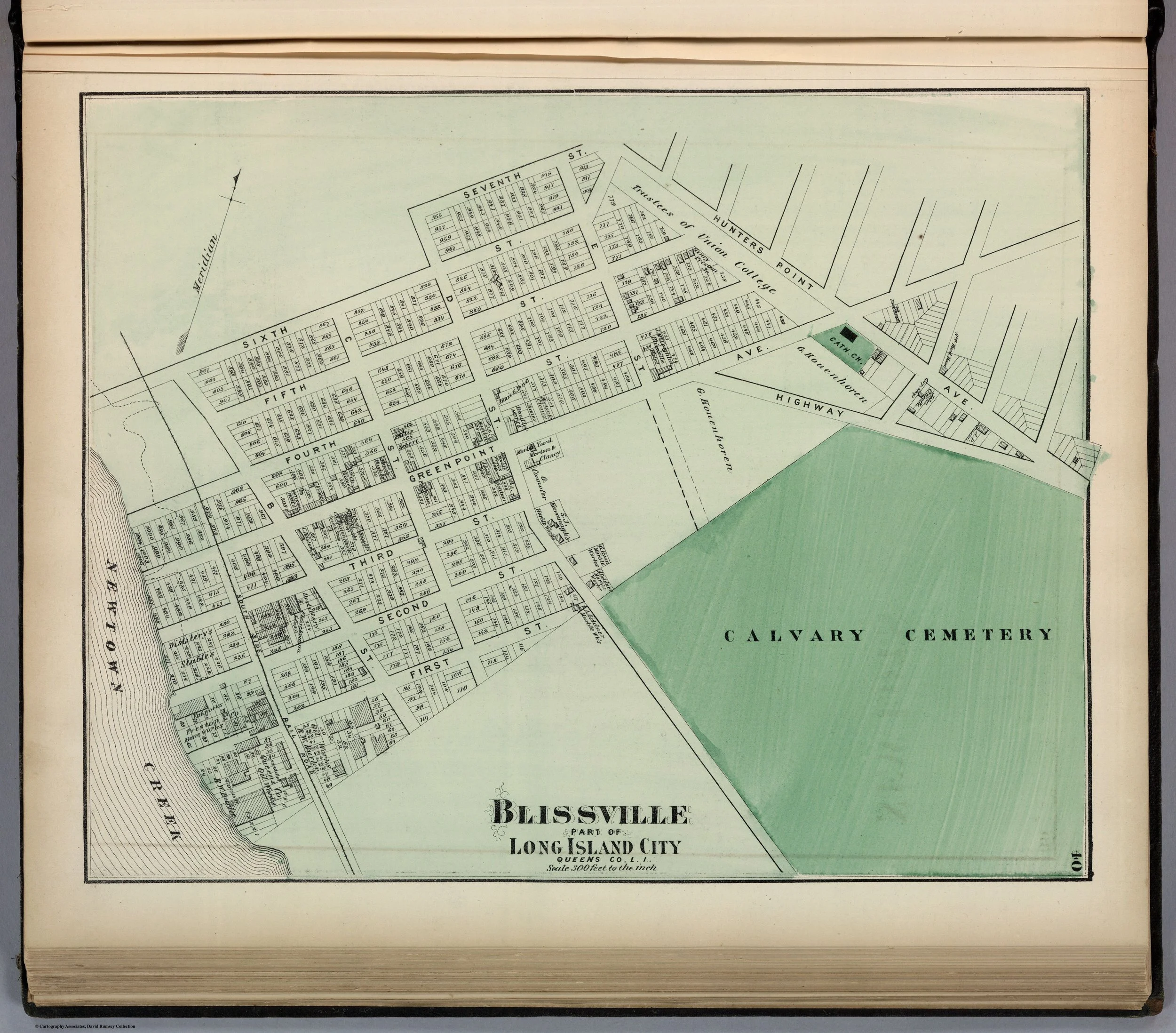
Blissville, L.I.C., Queens County, by F.W. Beers, 1873. David Rumsey Map Collection, Stanford Libraries.[3]
Blissville was never as famous as Astoria, as commercially powerful as Hunter’s Point, or as romantically remembered as Ravenswood. Yet for much of the nineteenth century, it was one of the essential communities of western Queens: a village of farms, roads, bridges, creek traffic, and eventually industry.
Its history unfolded along Newtown Creek, the waterway that separated Queens from Brooklyn and connected inland Long Island with the East River. Before factories and petroleum works transformed the creek into one of New York’s most heavily industrialized waterways, it was bordered by farms, old houses, mills, wharves, and roads leading toward Newtown, Maspeth, and Hunter’s Point.
Blissville’s story is therefore not merely local. It is the story of how an agricultural settlement at the edge of Newtown Creek became part of an industrial city.
A village on the creek
Blissville stood within the old Town of Newtown, near the southern and western reaches of what later became Long Island City. Its identity was shaped by Newtown Creek and by the roads that crossed or approached it.
The creek was a natural boundary but also a commercial artery. It linked the Queens shore to Brooklyn, Manhattan, and the East River. In the eighteenth and early nineteenth centuries, farm products could move by water toward urban markets. By the later nineteenth century, the same waterway attracted factories, warehouses, lumber yards, petroleum operations, and commercial shipping.[1]
The larger district was part of Newtown’s “Out Plantations,” a term used for the scattered settlements, farms, and waterfront holdings beyond the town center. Like Dutch Kills, Hunter’s Point, and Ravenswood, Blissville began as a rural place shaped by waterways rather than by a formal village grid.[1][1]
The name Blissville emerged in the nineteenth century. It commemorated Neziah Bliss, a major landholder and developer connected with the transformation of western Queens. The name reflects the period when farms and estates were being surveyed, marketed, and converted into lots, roads, and industrial sites. Blissville was not an old colonial place-name. It was a name of development.
The old farms of Blissville
Before urbanization, Blissville was a countryside of substantial farms.
Kelsey listed ten farms on the heights of Blissville during the Revolutionary period, including the holdings of Francis Duryea, John Debevoise, Abraham Payntar, Abraham Rapelye, William Payntar, Richard Bragaw, Abraham Schuyler, Andrews Bragaw, George Brinckerhoff, and William Morrell. The acreage varied, but the pattern was clear: the land was divided among old Newtown families whose names appeared repeatedly across western Queens.[1]
These were not isolated wilderness homesteads. They were part of a regional agricultural economy. Families raised livestock, cultivated crops, maintained houses and barns, and moved goods toward the East River markets. Roads connected them with Newtown, Williamsburg, and the growing settlements to the north and west.
By the nineteenth century, several old houses still survived. Kelsey described the Debevoise mansion, the Duryea homestead, and other manor houses as visible reminders of an earlier rural landscape. Their continued existence was remarkable because the district was already being remade by transportation, industry, and urban growth.[1]
War comes to Newtown Creek
The Revolutionary War brought military occupation to Blissville and the surrounding countryside.
Newtown was held by British forces from 1776 to 1783. Newtown Creek was especially important because it provided a sheltered water route close to Manhattan and Brooklyn. British vessels used the creek, and troops moved through the region as part of the larger campaign for New York.[1]
On September 15, 1776, the British crossing to Kips Bay began from boats concealed in Newtown Creek, according to Kelsey’s account. The operation helped secure British control of New York City. The creek’s quiet bends and inlets had become part of a major military movement.[1]
The surrounding farms suffered under occupation. British and Hessian troops used local houses, consumed supplies, and damaged property. Later histories described windowpanes marked with British officers’ names, military ovens on farms, and household goods destroyed or carried away. Such stories vary in their level of documentation, but they reflect a larger reality: the war entered domestic life through requisition, occupation, and displacement.[1]
The landscape of Blissville still bore these memories decades later. The old houses were not simply architectural relics; they were reminders of a community caught between the British-held city and the rest of Long Island.
From farming district to industrial corridor
The nineteenth century altered Blissville more radically than the Revolution had.
The first great change came through improved transportation. Roads leading from the creek toward Hunter’s Point, Newtown, and Brooklyn became increasingly important as traffic grew. The area’s proximity to Newtown Creek made it valuable for industries that needed water access, while its nearness to rail lines and ferries made it increasingly attractive to manufacturers.[1]
The second change came through the industrialization of Newtown Creek itself.
By the late nineteenth century, the creek had become a working waterway crowded with docks, commercial yards, and industrial plants. Lumber, grain, coal, oil, building materials, and manufactured goods moved through the district. The rural creek that had once carried farm produce became part of the industrial infrastructure of Greater New York.[1]
Kelsey’s account of the 1880 Standard Oil fire illustrates the scale and danger of the industrial waterfront. A fire that began aboard the bark Nictaux at Greenpoint spread through petroleum stores and vessels. Flaming barrels of naphtha drifted up Newtown Creek, igniting docks and lumber yards. In Blissville, the fire consumed large quantities of lumber, vessels, and waterfront property.[1]
The episode was dramatic, but it was not exceptional in kind. It revealed the new nature of the creek: a waterway of industrial concentration, flammable cargoes, crowded docks, and immense commercial risk.
Blissville and the bridge problem
The connection between Blissville and Brooklyn depended heavily on crossings of Newtown Creek.
For much of the nineteenth century, the bridges were a source of complaint. They could be narrow, unreliable, or inadequate to the growing volume of traffic. The creek separated the two sides politically and geographically, but commerce demanded better connections.
The old Penny Bridge, farther east, and other crossings in the Newtown Creek corridor were part of the wider road system linking Long Island City with Brooklyn and the rest of Queens. As industry expanded, these bridges became essential to the movement of workers, horses, wagons, raw materials, and finished goods.[1]
The problem was never only local. A bridge failure or traffic bottleneck could affect a much larger industrial network. Blissville’s location made it a hinge between Queens and Brooklyn, and its history cannot be understood without recognizing the importance of Newtown Creek as both barrier and route.
Joining Long Island City
In 1870, Blissville became part of the new City of Long Island City, alongside Astoria, Hunter’s Point, Ravenswood, Dutch Kills, Middletown, Steinway, and Bowery Bay.
The consolidation reflected the fact that these settlements were increasingly interconnected. They shared roads, watercourses, industries, transportation networks, and public-health problems. A scattered town government could no longer manage the needs of an urbanizing district.[1]
Blissville’s representation in the first Long Island City government showed its local importance. James Bradley of Blissville became the city’s first collector. The new municipality also took responsibility for the infrastructure that industrial growth demanded: roads, water, drainage, public safety, taxation, and eventually larger-scale improvement projects.[1]
The incorporation did not erase Blissville’s identity. For years afterward, residents continued to use the name for the neighborhood around the creek, its industrial establishments, and its old roads. But the village was now part of a larger city whose economic center increasingly lay at Hunter’s Point and along the riverfront.
A buried rural past
The old Blissville farms have almost entirely disappeared. Their barns, fields, lanes, orchards, and manor houses gave way to factories, warehouses, rail facilities, cemeteries, streets, and later urban redevelopment.
Yet the past is still present in the district’s geography.
Newtown Creek remains the key to understanding Blissville. It explains why the area first supported farms and creek commerce, why it later attracted industry, why bridges mattered so much, and why the neighborhood became part of Long Island City.
Blissville was never merely a forgotten village. It was a place where rural Queens met industrial New York. Its history captures the transformation of western Queens from agricultural hinterland to metropolitan infrastructure.
End Notes
[3] "Blissville, Part of Long Island City, Queens County, L.I.," by F.W. Beers, published by Beers, Comstock & Cline, 1873, in Atlas of Long Island, New York, from Recent and Actual Surveys and Records under the Superintendence of F.W. Beers (New York, 1873). From the David Rumsey Map Collection, David Rumsey Map Center, Stanford University Libraries. Accessed via: David Rumsey/ Blissville Map