Maspeth and English Kills: Newtown’s Early Colonial Frontier
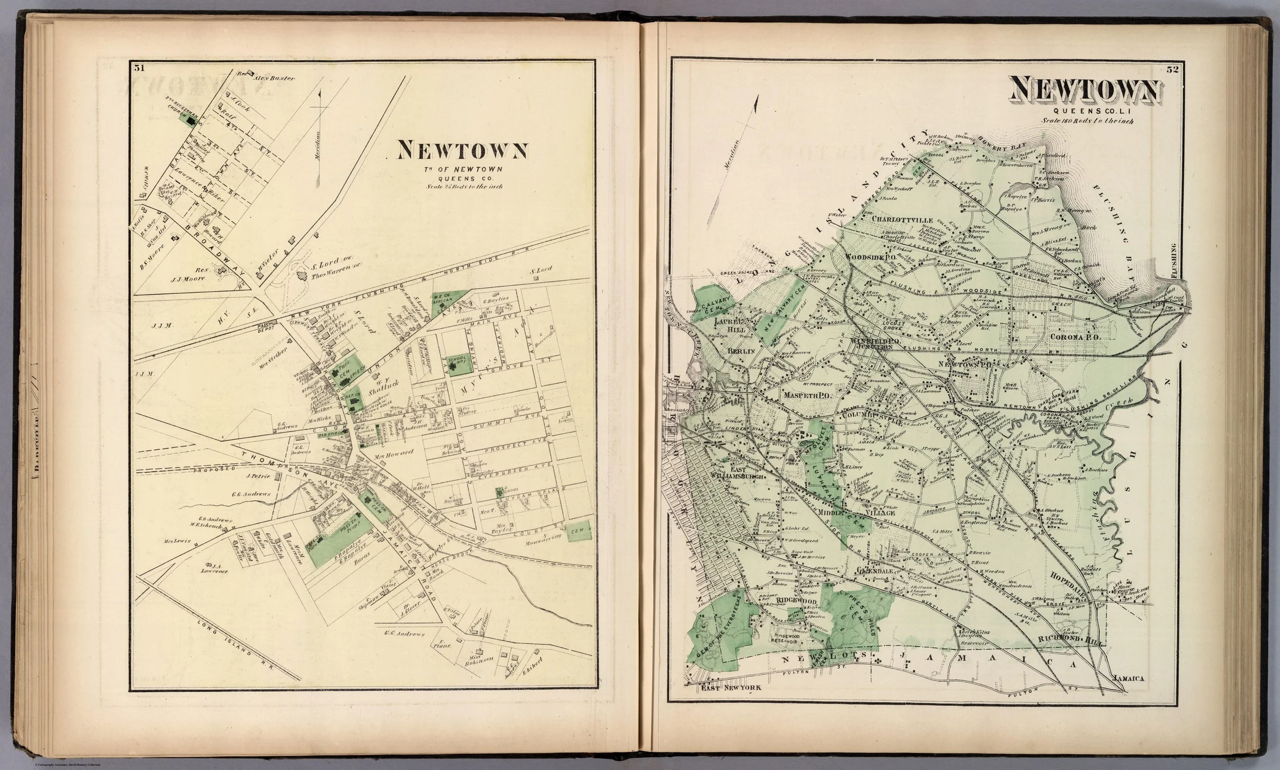
Newtown, Queens
Maspeth is often described today as an inland Queens neighborhood, defined by traffic corridors, cemeteries, industrial edges, and working-class homes. But its earliest history is inseparable from water.
Before roads and rail lines, the area was organized around Maspeth Creek, Newtown Creek, meadows, marshes, and the old routes that crossed western Long Island. In the seventeenth century, Maspeth was one of the first places in Queens where European settlers attempted to establish a community. The attempt ended in violence. The settlement was destroyed, the survivors scattered, and the area entered local history as a frontier marked by conflict, uncertainty, and repeated resettlement.
Its later name, English Kills, preserves another chapter of that past: a landscape of English settlers, Dutch administration, tidal creeks, and contested boundaries.
The first Maspeth settlement
The first European settlement in the Maspeth area was associated with the Rev. Francis Doughty, an English clergyman who received a large Dutch patent in 1640.
Doughty’s grant included a broad tract around Maspeth Kills—an old term for the waterways and marshes near the present Maspeth section of Queens. He and his associates encountered a sparsely settled but already inhabited Indigenous landscape, shaped by local communities, trails, fishing grounds, planting areas, and water routes.[1]
The settlement did not last.
During the conflict known as Kieft’s War, the Maspeth community was destroyed. Armbruster wrote that the settlement had grown to more than eighty inhabitants before it was wiped out. The surviving settlers fled or relocated, and the first effort to establish a European community at Maspeth came to an abrupt end.[1]
This episode is essential to understanding early Queens history. European settlement on western Long Island was not an uninterrupted process of farming and town-building. It involved conflict, displacement, military violence, land seizure, and the collapse of fragile colonial communities.
The older local histories often frame these events from the perspective of settlers and colonial authorities. A modern account must also recognize the devastating effects of Dutch colonial expansion on Indigenous communities across the region.
The return to the meadows
After the destruction of the original Maspeth settlement, new settlers returned to the larger area.
Armbruster described a later English settlement established on meadowland between the old Maspeth location and Flushing. This new place was called Middelburgh, or “middle village,” because it lay between older settlements. The name later evolved through a complicated sequence of local designations, eventually becoming part of the wider Town of Newtown.[1]
Maspeth itself remained a distinct place because of the waterways that defined it. The neighborhood stood near the junction of Newtown Creek and Dutch Kills Creek, close to the routes leading toward Brooklyn, Williamsburg, Flushing, and the western shoreline.
The landscape was low, wet, and productive. Creeks and marshes could be obstacles, but they also supported transport, fishing, milling, and agriculture. In the seventeenth and eighteenth centuries, local families used the waterways as practical connections to markets and neighboring communities.
English Kills and the Dutch-English frontier
The name English Kills referred to part of Newtown Creek near the boundary with Bushwick and Brooklyn.
“Kill” was the Dutch word for creek. The term reflects the mixed world of colonial Queens, where Dutch place names, English settlers, Indigenous geography, and changing political authority overlapped.
Armbruster noted that the land around the creek had been settled by English colonists and that the area became associated with the English Kills settlement. The name differentiated it from other parts of Newtown Creek, including Dutch Kills and Maspeth Kills.[1]
The English Kills area also marked a contested frontier between Newtown and Bushwick. The boundary between Queens and Brooklyn was not simply a line on a modern map. It emerged from colonial grants, local disputes, surveys, road use, waterways, and the gradual imposition of town and county government.
The old Penny Bridge stood near this wider creek landscape, connecting routes across the water and becoming an important landmark in the transportation history of western Queens.[2]
Farms and old houses
As political instability eased, the Maspeth and English Kills area developed into a farming district.
Families established homesteads along the roads and waterways. The landscape included houses, barns, fields, orchards, burial grounds, mills, and tidal crossings. The larger Newtown area was home to families whose names recur throughout western Queens history: Bragaw, Burroughs, Furman, Payntar, Rapelye, Riker, and others.[1][2]
Armbruster recorded several early houses and farms in the Maspeth vicinity, including the Burrough farm, the Furman house, and farms associated with the Brinckerhoff and Remsen families. These properties were part of a rural network extending from Newtown village toward the western shoreline.[1]
The landscape also preserved evidence of earlier Indigenous life. Armbruster noted that stone tools, arrowheads, and other materials were found in the Maspeth hills, while Kelsey and other nineteenth-century writers referred to shell heaps and burial sites throughout western Queens. Such evidence should not be treated as mere relic hunting. It represents the deep history of Indigenous occupation that colonial settlement attempted to overwrite.[1][2]
The Revolution and occupation
Like the rest of Newtown, Maspeth and English Kills fell under British occupation during the American Revolution.
The region’s strategic importance came from its roads and waterways. Newtown Creek connected the interior of western Queens to Brooklyn and the East River. Roads through Maspeth linked the creek settlements with Newtown village, Flushing, and the routes toward Jamaica.[2]
British forces occupied Newtown from 1776 to 1783. Farms were used for supplies, homes were occupied, and the countryside became part of the military geography surrounding New York City. While the major battles occurred elsewhere, the occupation shaped daily life in the rural districts.[2]
The legacy of the war survived in local stories, damaged homes, and family memory. The old farmhouses were not simply private residences. In wartime, they could become billets, supply points, or symbols of political loyalty.
Roads, turnpikes, and changing connections
The nineteenth century transformed Maspeth through transportation.
The Williamsburg and Jamaica Turnpike, built in the early nineteenth century, became one of the important routes crossing western Queens. It connected the growing communities of Brooklyn and Williamsburg with Jamaica and the interior of Long Island.[1]
The old roads through Maspeth became busier as the city expanded. The neighborhood’s position between Brooklyn, Newtown, and the future Long Island City gave it increasing importance. It was no longer simply an agricultural district; it was becoming a corridor.
Transportation also changed the pace of life. Travel that once depended on wagons, ferries, and rough roads became increasingly organized around turnpikes, street railways, and railroads. The roads that had served farms and local markets now carried commuters, laborers, building materials, and industrial goods.
Maspeth’s transformation was gradual, but it was decisive.
From rural frontier to urban Queens
Maspeth did not become part of Long Island City in the same way that Hunter’s Point, Astoria, or Dutch Kills did. Much of it remained within the Town of Newtown after Long Island City was incorporated in 1870.
Yet its history is inseparable from Long Island City’s growth.
Maspeth supplied roads, land, labor, and connections to the western waterfront. Newtown Creek tied it physically to Blissville, Hunter’s Point, Dutch Kills, and Brooklyn. The industrialization of the creek altered the surrounding environment, while the growth of Long Island City changed the economic value of nearby land.[2]
The old frontier settlement became part of an urbanizing borough. Its farms, creeks, roads, and old houses were gradually absorbed into the metropolitan landscape.
Still, the name Maspeth endures. It preserves the memory of one of the earliest and most difficult European settlements in Queens -- a place where colonial ambition met Indigenous resistance, where waterways shaped daily life, and where the rural past remained visible long after the city had begun to surround it.
