The Water Was the First Street
How ferries helped create Queens before bridges, tunnels, and subways took over
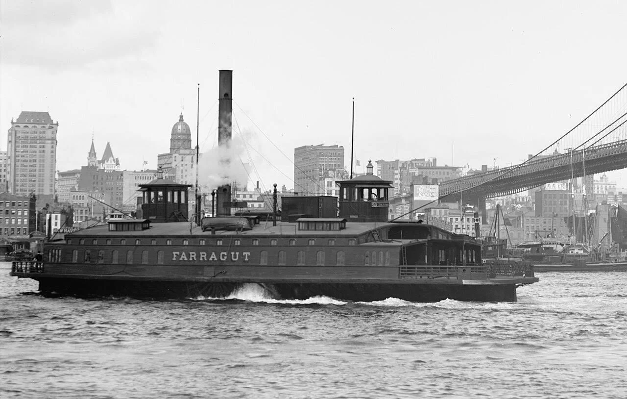
The Farragut ferry on the Fulton route between Brooklyn and Manhattan, circa 1895–1910
Long before Queens was stitched together by steel bridges and subway lines, people crossed by boat. To understand the borough’s earliest growth, you have to stop treating the East River as a barrier and start seeing it for what it was: the original highway.
People looking at New York on a map make a very natural mistake. They see water and think obstacle. That is because they are thinking like modern commuters, imprisoned by asphalt habits. But for much of New York’s history, water was not the thing that got in the way. Water was the thing that made movement possible.
That fact matters especially in Queens.
Before the great bridge age, before the subway age, and certainly before the age of expressways and congestion, the settlements that would become western Queens lived by shorelines, landings, creeks, and ferries. The borough was not first organized by interior boulevards. It was organized by access to water. If you want to understand why Astoria mattered, why Hunter’s Point became strategic, why Flushing flourished, and why so many later industrial districts emerged where they did, the ferry is one of the best places to begin.
Before Queens Was a Borough, It Was a Coastline
The early communities of Queens were coastal communities in the plainest sense. Newtown, Flushing, Jamaica, Ravenswood, Astoria’s antecedents at Hallett’s Cove, and the settlements along Newtown Creek and Flushing Bay all developed in relation to navigable water, however imperfectly navigable and however muddy the edges might have been.
In the seventeenth and eighteenth centuries, people did not wait around for ideal transportation systems to appear. They used what geography gave them. In western Long Island, that meant tidal creeks, inlets, bays, and the East River. The land route from one settlement to another might be slow, marshy, indirect, or seasonally miserable. Water, by contrast, could be efficient—assuming wind, tide, weather, and human competence behaved themselves, which was by no means guaranteed. History is full of confidence where nature supplied only probabilities.
Queens developed accordingly. Its shoreline settlements became points of exchange. Produce, livestock, oysters, timber, bricks, and later manufactured goods moved by water. So did people, news, and opportunity.
The Ferry as Urban Technology
A ferry is often treated as a quaint object, the sort of thing that belongs on a nostalgic postcard. That is unfair to the ferry and a little vain of us. Ferries were serious infrastructure. They linked labor to markets, households to jobs, farms to city consumers, and outlying settlements to the commercial gravity of Manhattan and Brooklyn.
The New York City Department of Records has neatly described the municipal ferry system’s long pattern as one of “rise, fall and rise again,” and that phrase is useful precisely because it reminds us that ferries were not incidental. They were part of the city’s core transit structure for centuries.[1]
Queens had multiple such connections over time. The Astoria Ferry, for instance, later connected East 92nd Street in Manhattan with Astoria from 1920 to 1936, until the Triborough Bridge made it expendable in the eyes of planners.[2] Another route linked Clason Point in the Bronx and College Point in Queens from 1921 to 1939.[3] These were late examples of an older principle: waterfront neighborhoods prospered when they could turn water crossings into regular commuter or commercial movement.
Hallett’s Cove, Hunter’s Point, and the Logic of the Shore
Your own site already points toward this pattern. Astoria before the skyline, Hell Gate and Hallett’s Point, Hunter’s Point as gateway—these places make the most sense when read as water-oriented geographies before they became rail and bridge geographies.
Hallett’s Cove mattered not because it sat in abstract proximity to Manhattan, but because it faced Manhattan across a crossable water route. Hunter’s Point became consequential because it offered a transfer edge between Long Island and the East River world of Manhattan. Newtown Creek, however foul it later became, was once a working transportation corridor and industrial armature. These were not peripheral spaces. They were interfaces.
That word is ugly but useful. Cities grow at interfaces: shore to ship, rail to ferry, factory to dock, worker to workplace.
What Ferries Reveal About Early Queens Society
Transportation history is never only about transportation. That would be like saying the circulatory system is only about plumbing.
Ferries reveal class, settlement, trade, and power. They show where people needed to go, who could pay to move, what goods mattered, and which neighborhoods could command political attention. A ferry landing is a clue. It tells you that repeated motion was important enough to formalize.
And formalized motion is one of the first signs of urbanization.
In early and pre-consolidation Queens, ferries helped bind western neighborhoods to Manhattan’s commercial life while allowing inland communities to orient themselves toward export and exchange. In some cases they supported modest local growth. In others they laid the groundwork for later transformations: industry, speculative real estate, commuter suburbs, and annexation into larger urban systems.
Then the Bridges Came
Of course, ferries did not vanish because they failed in some moral sense. They vanished because other infrastructures superseded them—or appeared to.
Bridges, tunnels, electrified railroads, streetcars, elevated lines, and eventually subways reorganized the terms of access. Once fixed links across the East River and Harlem River could move more people more predictably, ferries were pushed aside. Some routes disappeared quickly. Others lingered. But the logic had changed.
The important point is this: the later city did not erase the ferry city. It was built on top of it.
You can still see the older geometry beneath the newer one. The siting of districts, the orientation of streets, the location of industry, the rhythm of shoreline development—all of it bears the imprint of a time when the water was the road.
Conclusion:
Queens did not begin as a borough of subway stops. It began as a scattered edge of farms, coves, landings, inlets, and villages learning how to move by water. The ferry, in that world, was not picturesque decoration. It was structure.
And once you see that, a good deal of Queens history becomes easier to understand. Waterfront neighborhoods were not accidents. They were transportation facts before they became real estate stories.
Endnotes:
Image
“Farragut (1871 ferry),” cropped image, circa 1895–1910. From the Library of Congress Prints and Photographs Division, digital ID det.4a16764b. Public domain in the United States. Wikimedia Commons: File:Farragut (1871 ferry) cropped.jpg - Wikimedia Commons
Literary
[1] New York City Department of Records & Information Services, “The Rise, Fall, and Rise Again of the New York City Municipal Ferry System,” July 29, 2019, https://www.archives.nyc/blog/2019/7/29/ferries
[2] Ibid.
[3] Ibid.
[4] NYC Ferry, Wikipedia overview, accessed from user-provided search result, for summary of modern ferry rationale and route buildout.
[5] Brete Murphy, related neighborhood essays on Astoria, Hell Gate and Hallett’s Point, Hunter’s Point, Ravenswood, Dutch Kills, and Newtown Creek history, bretemurphy.com