Hunter’s Point to Rockaway
Waterfront growth, real estate ambition, and the new geography of access in Queens
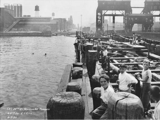
48th Ave Pier, Long Island City, August 1930 (photo).
The modern ferry does more than move commuters. In Queens, it maps where the city expects growth, where capital sees opportunity, and where old waterfront edges are being reimagined as front doors.
A waterfront can be many things. It can be a working shore, a dumping ground, a shipyard, a rail terminus, a windblown margin, a scenic promise, or a speculative fantasy with brochures.
Queens has had all of them.
That is why the ferry is so useful. It lets you watch the waterfront change jobs. A ferry landing is never just a place to board a boat. It is a declaration that a shoreline matters in some new way. Perhaps it matters to commuters. Perhaps to developers. Perhaps to tourists. Usually, if we are being honest, to all three.
From Hunter’s Point to the Rockaways, the return of ferry service helps us read a larger history of Queens: how working edges become residential frontiers, how neglected places are rediscovered once they can be marketed as connected, and how transportation quietly reorganizes what counts as valuable land.
Hunter’s Point: From Transfer Edge to Showcase Waterfront
Hunter’s Point has had more than one life, and none of them were accidental.
Historically, it was strategic because it was a point of exchange: rail met water there, and Manhattan was close enough across the East River to make the shoreline a hinge rather than a margin. As Long Island City emerged in the nineteenth century, Hunter’s Point became one of those places where infrastructure makes geography behave differently. It was not just on the edge of the city. It was a mechanism for entering it.
That is the old logic.
The new one is similar, but dressed more elegantly.
Today, the area’s modern ferry service and waterfront development announce Hunter’s Point not as a gritty transfer zone but as a residential and civic asset. The same shoreline once prized for industrial utility is now prized for access, views, and what real estate language likes to call lifestyle, as though neighborhoods were hatched in wellness brochures instead of conflict and capital.
But the pattern is clear enough. Transit and redevelopment move together. The ferry supports the story of the neighborhood as connected, desirable, and metropolitan in a polished way. It is hard to sell a waterfront district as remote when a boat glides from it to Manhattan.
Long Island City and the Reinvention of the Industrial Edge
Long Island City is perhaps the grandest Queens example of this broader transformation. Once assembled from old villages and industrial tracts into an urban municipality in 1870, it grew through exactly the kinds of connections ferries, rail lines, bridges, and waterfront infrastructure made possible.[1]
What changed in recent decades is not that transportation stopped shaping Long Island City. It is that the social meaning of transportation changed. Freight yards, factory slips, and industrial piers gave way, in part, to residential towers, parks, cultural uses, and commuter branding.
The modern East River ferry route serves that new Long Island City. It does not erase the industrial past; rather, it turns pieces of that past into scenery. That is a very New York trick. First the city builds industry. Then it condemns the ugliness. Then it rents out the view of what remains.
Astoria and the Prestige of Shoreline Access
Astoria’s relationship to ferry service tells a related story, though with its own distinct texture.
Historically, Astoria had ferry links that mattered enough to become formal municipal routes. The Astoria Ferry, operating between East 92nd Street and Astoria from 1920 until 1936, disappeared after the opening of the Triborough Bridge.[2] That older route belonged to the age when ferries still competed directly with fixed crossings.
The modern Astoria route belongs to something different. It is less an indispensable link than a selective enhancement. But such enhancements matter. They strengthen the appeal of shoreline neighborhoods, especially those already undergoing or resisting various kinds of residential pressure.
Justin Tyndall’s 2025 study suggests that ferry-connected areas have seen increased demand from middle-to-high-income workers, and that much of the direct commuting benefit accrues to those already better positioned geographically and economically to use the service.[3] Astoria fits that pattern uncomfortably well. It is precisely the sort of neighborhood where transit, waterfront identity, and real estate desirability intersect.
The Rockaways: Isolation, Recovery, and Selective Connection
The Rockaways pose a different problem.
Unlike western Queens waterfronts, which are entangled with Manhattan-facing redevelopment, the Rockaways have long been defined by both connection and isolation. They are close to the city, and yet often function transit-wise as though they are apologetically attached to it. The peninsula’s history includes resort development, rail access, storm vulnerability, and periodic civic neglect.
The ferry’s modern return here carries a symbolic burden larger than its ridership. After Hurricane Sandy, transportation resilience became a moral as well as logistical issue. A ferry route to Rockaway is therefore not just a matter of convenience. It reads as recognition.
But recognition is not the same thing as comprehensive investment.
The ferry offers a valued alternative, especially when subway service is disrupted or cumbersome. Yet by its very nature it remains selective. It does not reorganize the full transit landscape of the peninsula. It serves a corridor, a schedule, a shoreline subset. Still, in public imagination it looms large because it suggests that a place once treated as peripheral can again be seen from the water as part of the city’s main body.
Transportation as Real Estate Language
Here we arrive at the uncomfortable but necessary point: transit has a vocabulary, and developers learn it quickly.
A ferry landing says:
this neighborhood is accessible
this shoreline is usable
this district belongs on the mental map of affluent commuters
this place is not forgotten
That does not mean ferry service is cynical or fraudulent. It means infrastructure and valuation are intertwined.
Tyndall’s paper points toward this directly. He notes that ferry terminal areas saw worker population growth, especially among higher-income and professional sectors, and that these areas also experienced rent pressure.[4] The Race and Power Policy study you surfaced makes the same broader criticism from another angle, arguing that ferry investment can align with upscale waterfront growth rather than greatest transit need.[5]
Again, one need not shout to see what is happening. The evidence is doing enough shouting on its own.
What the Ferry Really Maps
If you draw ferry routes on a map of modern Queens, you are not only mapping water transit. You are mapping municipal confidence.
You are seeing where the city believes investment can stick.
Where a shoreline can become an address.
Where infrastructure can help convert edge into frontage.
That is why Hunter’s Point and Astoria matter in this story. That is why the Rockaways matter in a different one. All are waterfronts, yes. But each is being asked to perform a different urban role.
Conclusion
The ferry did not simply return to Queens. It returned to a new kind of waterfront.
In one place, it supports redevelopment.
In another, it softens isolation.
In another, it enhances prestige.
Everywhere, it reveals which shorelines the city now regards as active territory rather than leftover space.
That is the deeper story from Hunter’s Point to Rockaway. The water has not changed much. The city’s use of it has.
Endnotes
Images
“48th Ave Pier, Long Island City (August 1930),” photograph, L.I.C. Talk, https://lictalk.com/filler-cool-vintage-pic-in-long-island-city/ (accessed September 10, 2026).
Liturature
[1] Brete Murphy, “How Long Island City Was Created in 1870,” bretemurphy.com
[2] New York City Department of Records & Information Services, “The Rise, Fall, and Rise Again of the New York City Municipal Ferry System,” July 29, 2019, https://www.archives.nyc/blog/2019/7/29/ferries
[3] Justin Tyndall, “Estimating Commuter Benefits of a New Transit System: Evidence from New York City’s Ferry Service,” June 10, 2025.
[4] Ibid.
[5] The Institute on Race, Power and Political Economy, “A Case Study of the NYC Ferry and Fair Fares,” 2024, user-provided result.
[6] Brete Murphy, related articles on Astoria, Hunter’s Point, Long Island City, and Far Rockaway, bretemurphy.com