Bowery Bay and the Poor Bowery: Queens Before the Airport
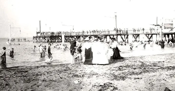
Bowery Bay Beach in 1894, via the Greater Astoria Historical Society
Before LaGuardia Airport, before parkways and runways, before North Beach became a name associated with aviation, the northeastern shore of Long Island City was known for farms, shell heaps, tidal water, and a curious colonial institution called the Poor Bowery.
The history of Bowery Bay is one of the oldest in western Queens. It includes early Dutch land grants, the Riker family, the Luyster estate, Rikers Island, farm roads, mills, orchards, and the gradual transformation of a rural shoreline into part of modern New York City.
It is also a reminder that the geography of Queens has changed dramatically. Shorelines moved. Creeks were filled. Islands were joined to the mainland or cut off by dredging. Farm country became industry, amusement grounds, airport land, and dense city neighborhoods.
A shore shaped by water
Bowery Bay lies on the northern edge of Queens, opening toward the East River and Long Island Sound. In the colonial era, the surrounding landscape included marshes, inlets, islands, creeks, and a broad shoreline that was far less regular than it appears today.
The region’s waterways made it useful for farming, fishing, transportation, and milling. They also made it difficult to govern and develop. Tides, shallow channels, and changing shorelines shaped everyday life long before engineers, dredges, and airport construction remade the area.[1]
The place was part of the old Town of Newtown and of the northwestern district later known as the “Out Plantations.” It stood near the boundary between the older inland settlements of Queens and the turbulent waters of Hell Gate and Long Island Sound.[1][2]
The area had long been part of an Indigenous landscape. Early local histories recorded shell heaps, burial sites, stone tools, and other evidence of Indigenous life, particularly around Bowery Bay. But these same histories often treated Indigenous people as a vanished population rather than as communities dispossessed by colonization. Modern readers should approach their language and conclusions critically.[1][2]
Hendrick Harmensen and the first Poor Bowery
The history of the Poor Bowery begins with Hendrick Harmensen, a Dutch blacksmith who acquired a large tract in 1640.
Harmensen’s grant extended from the bay southward along an old trail later associated with Bowery Bay Road and Dutch Kills. Kelsey described him as one of the first settlers in the territory later incorporated into Long Island City.[1]
After Harmensen’s death, his land came into the possession of the Dutch Reformed Church in New Amsterdam. It was used as a poor farm, or “armen bouwerij” in Dutch usage. From this function came the name Poor Bowery.[1]
The term “bowery” did not mean a city street or entertainment district. In colonial New Netherland, it referred to a farm or agricultural holding. The Poor Bowery was therefore a farm intended to support charitable or institutional purposes.
The name endured long after the original use of the land had changed.
Peter Luyster and the estate landscape
In 1656, Peter Luyster purchased the Poor Bowery property from its ecclesiastical owners. His acquisition began a long period in which the land was held and developed as a private estate.
Luyster’s descendants retained parts of the property for generations. The land included a large stretch of the Bowery Bay and North Beach shoreline and, according to Kelsey, once included Luyster Island. The estate later became associated with the Riker, Rapelye, Moore, Lawrence, Berrian, and Kouwenhoven families.[1]
The region was fertile and agricultural. Farms produced crops, livestock, and orchard fruit for local use and metropolitan markets. The landscape was not isolated, but it retained a rural character well into the nineteenth century.
A gristmill stood near the mouth of a stream in the vicinity of Fish Point. Cornelius Luyster laid the foundation for a mill there in 1668. Later owners continued the milling tradition, and in the nineteenth century Thomas B. Jackson erected a mill on the old foundations.[1][2]
The story of the mill demonstrates how waterways organized local life. A creek or stream could power machinery, receive boats, move grain, and connect a farm district with the East River.
The Riker family and Rikers Island
No family is more closely associated with the old Poor Bowery than the Rikers.
Abraham Rycken, or de Rycke, received land in the area during the seventeenth century. He later acquired the island that became known as Rikers Island. The island passed through generations of the family and remained linked to the larger estate landscape of northern Queens.[1]
The Riker family’s importance extended beyond landholding. Members of the family were active in church life, local government, and the social networks of colonial Newtown. Kelsey noted that Abraham Riker was involved in the organization of the Dutch Church at Newtown and that families sometimes walked considerable distances to worship there.[1]
The island itself was once a rural family holding, not an institutional complex. Its later history as a penitentiary site has largely overshadowed its earlier identity as part of the agricultural world of Bowery Bay and the Poor Bowery.
The name survives, but its meaning has changed completely.
Farm roads, orchards, and old houses
Bowery Bay remained a farming district for generations.
The old roads connected the bay with Astoria, Dutch Kills, Newtown, and Flushing. Farmhouses, barns, family burial grounds, and orchards marked the landscape. The Moore family held land in the district, and the old Moore mansion was remembered in late nineteenth-century accounts as one of the surviving relics of agricultural Queens.[1]
The neighborhood was also known for the Newtown pippin, an apple celebrated in the nineteenth century for its quality and market value. Kelsey noted that pippins grown on the grounds of the old Moore homestead had sold for extraordinary prices. The trees themselves had become historical relics by the time he wrote.[1]
Such details are more than nostalgic curiosities. They reveal an economy based on land, horticulture, water access, and proximity to New York markets. Bowery Bay was rural, but it was not remote. Its orchards, mills, and farms were part of the food system of the metropolitan region.
North Beach and the changing shoreline
The old shoreline around Bowery Bay and North Beach was dramatically different from the modern landscape.
Kelsey described North Beach as extending westward from Fish Point, including land once connected with Luyster Island and the old Poor Bowery estate. The water came much closer to areas later occupied by streets, houses, factories, amusement grounds, and airport facilities.[1]
By the late nineteenth century, the area was changing rapidly. Land was filled. Shorelines were bulkheaded. Transportation improved. Industry moved outward from the older waterfront districts. North Beach became associated with recreation and commercial development before its later transformation into airport land.
The old estate landscape did not disappear in a single moment. It was gradually broken apart through inheritance, sale, subdivision, public works, and industrial expansion.
The same process reshaped much of Long Island City: land once defined by water and farms became city blocks and infrastructure.
Bowery Bay enters Long Island City
In 1870, Bowery Bay and the surrounding northeastern district became part of Long Island City.
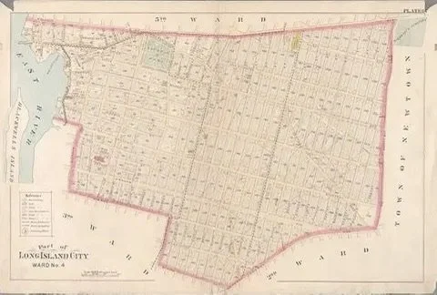
Bowery Bay map, Plate 6, NYPL public domain.
The incorporation joined the old settlements of Astoria, Hunter’s Point, Ravenswood, Dutch Kills, Blissville, Middletown, Steinway, and Bowery Bay under one municipal government. For Bowery Bay, this meant that a rural shoreline of farms and estates became part of an expanding industrial city.[1]
The new city’s boundaries reached north and east to Bowery Bay. The Fifth Ward included much of the area between the East River, Bowery Bay, Flushing Avenue, and the surrounding roads.[1]
Municipal incorporation did not immediately erase the older rural identity. But it placed Bowery Bay within a city increasingly oriented toward industry, railroads, utilities, real estate development, and metropolitan growth.
The old Poor Bowery had become part of Long Island City’s future.
What the Poor Bowery still tells us
The Poor Bowery is one of those names that seems strange until its history is recovered.
It preserves the memory of a seventeenth-century Dutch poor farm. It recalls an era when “bowery” meant a farmstead, when church institutions held agricultural land, and when the northern shore of Queens was a landscape of creeks, fields, and islands.
Bowery Bay, North Beach, and Rikers Island are now associated with aviation, recreation, public institutions, and urban infrastructure. Yet beneath those later meanings lies an older story of colonial grants, estate farming, mills, orchards, and Indigenous dispossession.
The name Poor Bowery survives because geography remembers what buildings forget.
Endnotes
Images
Bowery Bay Beach in 1894, via the Greater Astoria Historical Society
Image credit: New York Public Library, “Plate 6: [Bounded by Franklin Street, Flushing Avenue, Old Bowery Bay Blvd., Jackson Avenue, Western Avenue, Lockwood Avenue, Pierce Avenue, Sherman Street, Broadway, Boulevard, Fulton Street and Mills Street],” public domain, via PICRYL, https://nypl.getarchive.net/amp/topics/old+bowery+bay+blvd
Literary
This article draws primarily on J. S. Kelsey, History of Long Island City, New York (1896), especially its discussion of Hendrick Harmensen, the Poor Bowery, Peter Luyster, the Riker family, Rikers Island, Bowery Bay, North Beach, and the Moore estate. Eugene L. Armbruster, Long Island: Its Early Days and Development (1914), provides additional context for Newtown, the Poor Bowery, and the northeastern shore of Long Island City. Both are valuable period histories but should be read critically, especially in their treatment of Indigenous peoples, place names, colonial land transfers, slavery, and race.[1][2]